IMAGES TAKEN NEAR TO
Anchor Hill, MARGATE, CT9 1SE
Introduction
This page details the photographs taken nearby to Anchor Hill, CT9 1SE by members of the Geograph project.
The Geograph project started in 2005 with the aim of publishing, organising and preserving representative images for every square kilometre of Great Britain, Ireland and the Isle of Man.

There are currently over 7.5m images from over14,400 individuals and you can help contribute to the project by visiting https://www.geograph.org.uk
Image Map
Images are licensed for reuse under creativecommons.org/licenses/by-sa/2.0
Notes
- Clicking on the map will re-center to the selected point.
- The higher the marker number, the further away the image location is from the centre of the postcode.
Image Listing (187 Images Found)
Images are licensed for reuse under creativecommons.org/licenses/by-sa/2.0
Image
Details
Distance

2
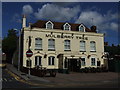
The Mulberry Tree, Dane Road
Pub on the junction with Bath Road
Image: © Keith Edkins
Taken: 22 Jun 2015
0.05 miles

10
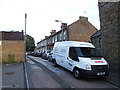
Looking northeast up Dane Hill
Looking across Dane Road from Addington Street, the white-painted building with scaffolding erected on its frontage and at the side is the restaurant ‘Beano’. Up the hill, on the left, scaffolding has been erected on the frontages of numbers 5 and 5A.
Image: © John Baker
Taken: 22 Jun 2014
0.07 miles