IMAGES TAKEN NEAR TO
Ramsgate Road, MARGATE, CT9 1LJ
Introduction
This page details the photographs taken nearby to Ramsgate Road, CT9 1LJ by members of the Geograph project.
The Geograph project started in 2005 with the aim of publishing, organising and preserving representative images for every square kilometre of Great Britain, Ireland and the Isle of Man.

There are currently over 7.5m images from over14,400 individuals and you can help contribute to the project by visiting https://www.geograph.org.uk
Image Map
Images are licensed for reuse under creativecommons.org/licenses/by-sa/2.0
Notes
- Clicking on the map will re-center to the selected point.
- The higher the marker number, the further away the image location is from the centre of the postcode.
Image Listing (85 Images Found)
Images are licensed for reuse under creativecommons.org/licenses/by-sa/2.0
Image
Details
Distance
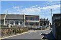
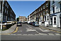
2
First & Last, Vicarage Place, Margate
Image: © Chris Whippet
Taken: 21 Sep 2014
0.02 miles
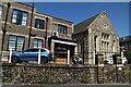
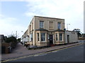
3

First and Last no more
Former pub now appears to be a private house
Image: © Keith Edkins
Taken: 24 Jun 2015
0.02 miles
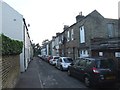
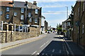
4

Looking north-northeast up Vicarage Crescent
Numbers 18 & 20 (the nearer house) have had scaffolding erected on their frontages. It appears that renovation is being carried out.
Image: © John Baker
Taken: 13 Jan 2016
0.03 miles