IMAGES TAKEN NEAR TO
High Street, MARGATE, CT9 1LA
Introduction
This page details the photographs taken nearby to High Street, CT9 1LA by members of the Geograph project.
The Geograph project started in 2005 with the aim of publishing, organising and preserving representative images for every square kilometre of Great Britain, Ireland and the Isle of Man.

There are currently over 7.5m images from over14,400 individuals and you can help contribute to the project by visiting https://www.geograph.org.uk
Image Map
Images are licensed for reuse under creativecommons.org/licenses/by-sa/2.0
Notes
- Clicking on the map will re-center to the selected point.
- The higher the marker number, the further away the image location is from the centre of the postcode.
Image Listing (279 Images Found)
Images are licensed for reuse under creativecommons.org/licenses/by-sa/2.0
Image
Details
Distance
1
Back garden of 152, High Street
Seen from Park Place, it appears to have become a demolition site.
Image: © John Baker
Taken: 13 Jan 2016
0.01 miles
2
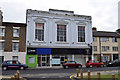
From Square to Ring
The former Masonic Hall in the High Street is now a boxing gym. Mid 19th century, Grade II listed
Image: © Keith Edkins
Taken: 23 Jun 2015
0.03 miles
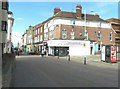
3
Masonic Hall, High Street
It is a grade II listed building that dates from the mid 19th century and was built as a Masonic Hall. It is described as having two stuccoed storeys with a parapet, four composite pilasters, three sashes set in moulded architraves with an ordinary pediment over the centre sash and curved pediments over the side sashes. The ground floor has a mid 19th century shopfront with pilasters and a three panelled door
http://www.britishlistedbuildings.co.uk/en-356591-166-and-168-high-street-kent#.VqfM1sLcvcc
It appears to be undergoing a renovation to the exterior.
Image: © John Baker
Taken: 13 Jan 2016
0.03 miles
4

Grosvenor Place, Margate
Imposing terrace
Image: © Keith Edkins
Taken: 24 Jun 2015
0.03 miles
5
Dera's Internet Cafe
Situated on the corner of the High Street and Mill Lane with pargeting between the windows on the second floor.
Image: © John Baker
Taken: 8 Sep 2013
0.03 miles
6
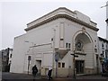
Cinema De Luxe, Margate
This building on the junction of Grosvenor Hill and High Street, was built as the Cinema de Luxe in 1914-15. It is Grade II listed. The cinema closed in 1987. It is now used as a church.
See http://www.britishlistedbuildings.co.uk/en-485480-cinema-de-luxe-kent for more details on the building.
Image: © David Anstiss
Taken: 23 Mar 2013
0.04 miles
7
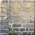
OS benchmark, High Street
Listed as 21.07m above OSDN
Image: © Keith Edkins
Taken: 23 Jun 2015
0.04 miles
8
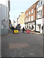
Looking north along the High Street
The yellow road sign indicates that the High Street will be closed from 11-13 January. The lorry is parked where the Image is taking place; it is carrying an excavator, so the presence of these vehicles must be linked to why the road is closed.
Image: © John Baker
Taken: 13 Jan 2016
0.05 miles
9
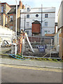
Ongoing erection of a building at 125, High Street
Planning permission has been granted by Thanet District Council under application number F/TH/15/0383 for the “erection of 3-storey building to accommodate six 2 bedroom flats”. A former view of Image shows the gap, where the building is now being erected. This image shows the Image after completion.
Image: © John Baker
Taken: 6 Nov 2016
0.05 miles
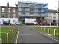
10
Block of flats, 125, High Street
Planning permission was granted by Thanet District Council under application number F/TH/15/0383 for the “erection of 3-storey building to accommodate six 2 bedroom flats”.
This image shows the Image
Image: © John Baker
Taken: 30 Jul 2017
0.05 miles