IMAGES TAKEN NEAR TO
Herbert Place, MARGATE, CT9 1AU
Introduction
This page details the photographs taken nearby to Herbert Place, CT9 1AU by members of the Geograph project.
The Geograph project started in 2005 with the aim of publishing, organising and preserving representative images for every square kilometre of Great Britain, Ireland and the Isle of Man.

There are currently over 7.5m images from over14,400 individuals and you can help contribute to the project by visiting https://www.geograph.org.uk
Image Map
Images are licensed for reuse under creativecommons.org/licenses/by-sa/2.0
Notes
- Clicking on the map will re-center to the selected point.
- The higher the marker number, the further away the image location is from the centre of the postcode.
Image Listing (474 Images Found)
Images are licensed for reuse under creativecommons.org/licenses/by-sa/2.0
Image
Details
Distance
1
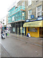
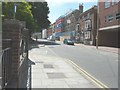
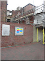
103, High Street
The scaffolding seems to indicate that the shop is being renovated.
Image: © John Baker
Taken: 15 Oct 2019
0.01 miles
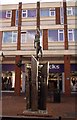
2
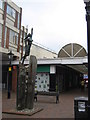
Sculpture in Margate Shopping Centre
In a open square. Near a walkway to the High Street.
Image: © David Anstiss
Taken: 11 Sep 2010
0.02 miles
4
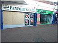
Penfold?s & Noobus
Two derelict stores located in The Centre Shopping Arcade.
Image: © John Baker
Taken: 9 Dec 2018
0.03 miles
5
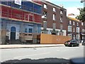
Listed buildings in Hawley Square
The building, with the blue safety netting covering its frontage, is numbers 47 and 48, Hawley Square, the home of the Make A Wish Foundation. It is grade II listed, dates from the 18th century and was originally two houses converted to one http://www.britishlistedbuildings.co.uk/en-356570-47-and-48-hawley-square-kent A couple of building applications have been applied for through Thanet District Council: F/TH/13/0232 and L/TH/13/0234. The details are the same for both applications, “erection of a four storey rear extension with alteration to roof to create a triple-pitch roof together with alterations to rear wall”.
The building to its right is numbers 49 and 50 Hawley Square and was gutted by fire on 6 May 2008. It dates from the late 18th century and is grade II listed http://margatearchitecture.blogspot.co.uk/2008/05/another-listed-building-in-margate-goes.html I assume the scaffolding has been erected to prevent the building collapsing. This is how the buildings appeared almost a year ago Image
Image: © John Baker
Taken: 22 Jun 2014
0.03 miles
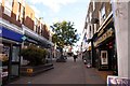
6
Pathway to The Centre in Margate
The Centre is a shopping precinct by the High Street.
Image: © Steve Daniels
Taken: 12 Oct 2012
0.04 miles
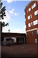
8
Erection of a building at 125, High Street
In June 2014, the site appeared as a Image
Planning permission has been granted by Thanet District Council under application number F/TH/15/0383 for the “erection of 3-storey building to accommodate six 2 bedroom flats”.
Image: © John Baker
Taken: 13 Jan 2016
0.04 miles
9
Back of 49 and 50, Hawley Square
This is the front of Image I think that if wasn’t for the scaffolding, the building would collapse.
Image: © John Baker
Taken: 6 Nov 2016
0.04 miles
10
47-50 Hawley Square
The building on the left is numbers 47 and 48, Hawley Square, the home of the Make A Wish Foundation. It is grade II listed, dates from the 18th century and was originally two houses converted to one http://www.britishlistedbuildings.co.uk/en-356570-47-and-48-hawley-square-kent A couple of building applications have been applied for through Thanet District Council: F/TH/13/0232 and L/TH/13/0234. The details are the same for both applications, “erection of a four storey rear extension with alteration to roof to create a triple-pitch roof together with alterations to rear wall”.
The building on the right is numbers 49 and 50 Hawley Square and was gutted by fire on 6 May 2008. It dates from the late 18th century and is grade II listed http://margatearchitecture.blogspot.co.uk/2008/05/another-listed-building-in-margate-goes.html
Image: © John Baker
Taken: 28 Jul 2013
0.04 miles