IMAGES TAKEN NEAR TO
Elm Grove, WESTGATE-ON-SEA, CT8 8LZ
Introduction
This page details the photographs taken nearby to Elm Grove, CT8 8LZ by members of the Geograph project.
The Geograph project started in 2005 with the aim of publishing, organising and preserving representative images for every square kilometre of Great Britain, Ireland and the Isle of Man.

There are currently over 7.5m images from over14,400 individuals and you can help contribute to the project by visiting https://www.geograph.org.uk
Image Map
Images are licensed for reuse under creativecommons.org/licenses/by-sa/2.0
Notes
- Clicking on the map will re-center to the selected point.
- The higher the marker number, the further away the image location is from the centre of the postcode.
Image Listing (97 Images Found)
Images are licensed for reuse under creativecommons.org/licenses/by-sa/2.0
Image
Details
Distance
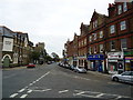
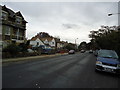
2
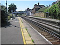
Westgate-on-Sea railway station, Kent
Opened in 1871 by the London, Chatham & Dover Railway on their line from Faversham to Ramsgate Harbour. View west towards Faversham and Chatham.
Image: © Nigel Thompson
Taken: 25 Jul 2012
0.07 miles
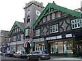
4
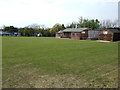
Westgate-on-Sea Cricket Club
Off St. Mildred's Road and Canterbury Road.
Image: © Jonathan Billinger
Taken: 25 Apr 2007
0.08 miles
5
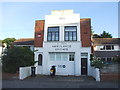
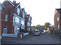
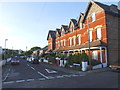
St. John Ambulance Brigade, Westgate-on-Sea
Image: © Chris Whippet
Taken: 5 Jun 2014
0.08 miles
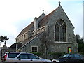
10

St Saviour, Westgate-on-Sea, Kent - Chancel
Image: © John Salmon
Taken: 14 Oct 2009
0.09 miles