1
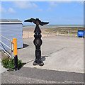
Memorial seat, St Mildred's Bay, Westgate-on-Sea
The plaque on the seat reads " Donated 2019 by Westgate-on-Sea Heritage Centre to commemorate the Royal Navy Air Service Station Westgate 1914-1920 and all who flew from St. Mildred's Bay to defend our shores".
Image: © pam fray
Taken: 8 Mar 2020
0.01 miles
2
St Mildred's Bay beach huts
Image: © Robert Eva
Taken: 25 Jan 2018
0.01 miles
3
Marine Heights, Beach Rd, St Mildred's Bay
Image: © N Chadwick
Taken: 4 Jul 2009
0.02 miles
4
Memorial seat, St Mildred's Bay, Westgate-on-Sea
The plaque on the seat reads "Donated by Westgate-on-Sea Heritage Centre to commemorate Civil Volunteers, ARP wardens, Home Guard, firemen, firewatchers, police, ambulance and WVS members who provided safety and comfort to Westgate in the dark days of the 2nd World War 1939-1945".
Image: © pam fray
Taken: 8 Mar 2020
0.02 miles
5
The Beach Caf?, St. Mildred's Bay
Once boasting "Westgate's Finest Fish & Chips", it is now a derelict site at the eastern end of the bay.
Image: © pam fray
Taken: 2 Jun 2016
0.02 miles
6
St Mildred's Bay slipway
A high tide, combined with a strong northerly onshore wind had produced large waves and a lot of foam, which had accumulated on the slipway. Pieces were becoming detached and blowing around.
Image: © Paul Harrop
Taken: 2 Jun 2016
0.03 miles
7
St Mildred?s Bay
View from the promenade leading to St Mildred’s Gardens.
Image: © John Baker
Taken: 10 Jul 2022
0.03 miles
8
Slipway, St Mildred's Bay
Image: © N Chadwick
Taken: 4 Jul 2009
0.04 miles
9
Millennium milepost, St Mildred's Bay
Rowe type, points left to Birchington 2M, Herne Bay 10M; right to Margate 2M Broadstairs 7M. No time trail disk.
Image: © Keith Edkins
Taken: 21 Jun 2015
0.05 miles
10
Beach huts, St Mildred's Bay
Image: © N Chadwick
Taken: 4 Jul 2009
0.05 miles


