IMAGES TAKEN NEAR TO
Cuthbert Road, WESTGATE-ON-SEA, CT8 8FD
Introduction
This page details the photographs taken nearby to Cuthbert Road, CT8 8FD by members of the Geograph project.
The Geograph project started in 2005 with the aim of publishing, organising and preserving representative images for every square kilometre of Great Britain, Ireland and the Isle of Man.

There are currently over 7.5m images from over14,400 individuals and you can help contribute to the project by visiting https://www.geograph.org.uk
Image Map
Images are licensed for reuse under creativecommons.org/licenses/by-sa/2.0
Notes
- Clicking on the map will re-center to the selected point.
- The higher the marker number, the further away the image location is from the centre of the postcode.
Image Listing (102 Images Found)
Images are licensed for reuse under creativecommons.org/licenses/by-sa/2.0
Image
Details
Distance
2
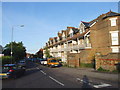
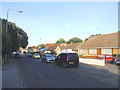
Domneva Road
This is taken from near the railway bridge. The sea can be seen in the distance.
Image: © Marathon
Taken: 6 Sep 2015
0.02 miles
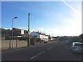
3
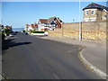
Domenva Road Bridge
This road leads from Sea Road towards the A28 Canterbury Road.
It passes single-file over the railway between Birchington and Westgate.
Image: © David Anstiss
Taken: 20 Feb 2011
0.04 miles
9
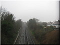
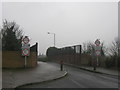
Railway to Birchington (2)
As seen from Image
This line leads from Margate (via Westgate-on-Sea) towards Birchington and then onwards to London (via Herne Bay and Faversham).
In the background is Hengist Road bridge.
Image: © David Anstiss
Taken: 20 Feb 2011
0.08 miles
10

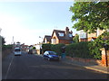
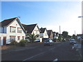
St. Michaels
Grade II Listed Convalescent home at the junction of Domneva Road (on the left) and Elm Grove (on the right).
See http://www.britishlistedbuildings.co.uk/en-441069-st-micheal-s-margate for more details about the building.
Image: © David Anstiss
Taken: 20 Feb 2011
0.08 miles