IMAGES TAKEN NEAR TO
Mill Lane, BIRCHINGTON, CT7 9TX
Introduction
This page details the photographs taken nearby to Mill Lane, CT7 9TX by members of the Geograph project.
The Geograph project started in 2005 with the aim of publishing, organising and preserving representative images for every square kilometre of Great Britain, Ireland and the Isle of Man.

There are currently over 7.5m images from over14,400 individuals and you can help contribute to the project by visiting https://www.geograph.org.uk
Image Map
Images are licensed for reuse under creativecommons.org/licenses/by-sa/2.0
Notes
- Clicking on the map will re-center to the selected point.
- The higher the marker number, the further away the image location is from the centre of the postcode.
Image Listing (23 Images Found)
Images are licensed for reuse under creativecommons.org/licenses/by-sa/2.0
Image
Details
Distance
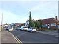
1
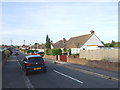
Mill Row, off Canterbury Road, Birchington
Mill Row is a tiny lane off Canterbury Road, adjacent to the junction of that road with Essex Gardens, which leads to a footpath going to Great Brooksend Farm. It is, therefore, nothing more than a small access road for the farm and the few houses which are on this road. On adjacent Mill Lane there is a beautiful house set back from the road, but it is rather hidden by hedgerows and ivy to get a decent photo. View taken looking west-southwest.
Image: © Robert Lamb
Taken: 14 Jun 2008
0.02 miles
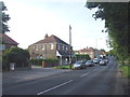
2
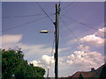
1950s Stanton and Staveley concrete lamp post on Essex Gardens
Essex Gardens had this lovely 1950s Stanton and Staveley concrete lamp post with a Revo Prefect lantern on its turf, until the council replaced it earlier this year with a modern lamp and column. A fellow streetlight enthusiast of mine actually lives here and it was both of us who discovered this little treasure! One thing which strikes me as odd on the OS map is that Essex Gardens is shown as a B road, which is hardly true as it's just an ordinary side street! To my knowledge, the only B road in this square is Minnis Road, which is where this road leads to. How strange! View taken looking northwest.
Image: © Robert Lamb
Taken: 14 Jun 2008
0.05 miles
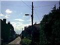
5
Telegraph pole-mounted streetlight on Quex View Road
Quex View Road is lit end-to-end with these quintessentially rural lamp posts mounted on telegraph poles. The lamp gets its power by a green power box located halfway up the pole, which is triggered and connected to by the photocell on top of the lamp (this is the device that detects low levels of daylight and illuminates the lamp when dusk falls). View taken looking east-southeast towards Quex Park, hence the name of the road.
Image: © Robert Lamb
Taken: 14 Jun 2008
0.10 miles
7
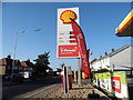
Shell petrol station on Canterbury Road
Image: © David Howard
Taken: 30 Jun 2018
0.13 miles
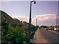
8
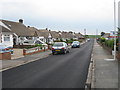
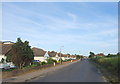
Lancaster Gardens
A straight road of bungalows. Junction with Essex Gardens at bottom.
Image: © Oast House Archive
Taken: 24 Jun 2010
0.14 miles
9
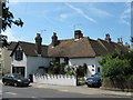
April Cottage
On the A28 Canterbury Road.
Image: © David Anstiss
Taken: 23 May 2011
0.15 miles