IMAGES TAKEN NEAR TO
Alfred Road, BIRCHINGTON, CT7 9ND
Introduction
This page details the photographs taken nearby to Alfred Road, CT7 9ND by members of the Geograph project.
The Geograph project started in 2005 with the aim of publishing, organising and preserving representative images for every square kilometre of Great Britain, Ireland and the Isle of Man.

There are currently over 7.5m images from over14,400 individuals and you can help contribute to the project by visiting https://www.geograph.org.uk
Image Map
Images are licensed for reuse under creativecommons.org/licenses/by-sa/2.0
Notes
- Clicking on the map will re-center to the selected point.
- The higher the marker number, the further away the image location is from the centre of the postcode.
Image Listing (73 Images Found)
Images are licensed for reuse under creativecommons.org/licenses/by-sa/2.0
Image
Details
Distance


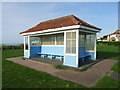
5
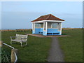
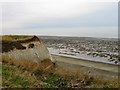
Sheltered Seating Area, Minnis Bay
This is a quintessentially British seaside feature.
Image: © Danny P Robinson
Taken: 3 Mar 2013
0.08 miles
6
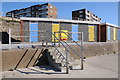
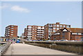
Beach huts and apartment blocks
Beach huts and apartment blocks overlooking Minnis Bay at Birchington.
Image: © Philip Halling
Taken: 15 Oct 2011
0.08 miles
8
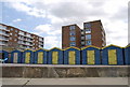
Colour Co-ordinated Beach Huts, Minnis Bay
Image: © N Chadwick
Taken: 4 Jul 2009
0.08 miles