IMAGES TAKEN NEAR TO
Semaphore Road, BIRCHINGTON, CT7 9JP
Introduction
This page details the photographs taken nearby to Semaphore Road, CT7 9JP by members of the Geograph project.
The Geograph project started in 2005 with the aim of publishing, organising and preserving representative images for every square kilometre of Great Britain, Ireland and the Isle of Man.

There are currently over 7.5m images from over14,400 individuals and you can help contribute to the project by visiting https://www.geograph.org.uk
Image Map
Images are licensed for reuse under creativecommons.org/licenses/by-sa/2.0
Notes
- Clicking on the map will re-center to the selected point.
- The higher the marker number, the further away the image location is from the centre of the postcode.
Image Listing (64 Images Found)
Images are licensed for reuse under creativecommons.org/licenses/by-sa/2.0
Image
Details
Distance
1
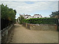
Driveway off Grenham Road, Birchington
Whilst walking down Grenham Road, the castellated house down this driveway caught my attention.
Image: © Marathon
Taken: 17 Sep 2010
0.04 miles

3
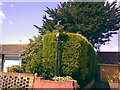
An old Victorian-style lamp post in a front garden (yet again!)
What is it with Birchingtonians and having old lamp posts in their front gardens? Yet another house, this time on the driveway featured in Image, has a Victorian lamp post in its front garden, but of a different kind. This one looks very similar to the modern replicas of such a design seen on many roads today, but I think this one probably originally ran a tungsten or GLS lamp instead of a modern one. I've posted onto a streetlight enthusiast's website to get it identified, and it is thought it was made by a company called Falks Beaufort.
Image: © Robert Lamb
Taken: 22 Jun 2008
0.09 miles
4
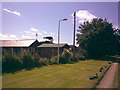
Street light not lighting a street
A rather daftly placed streetlight here - it isn't lighting a street at all! Instead, each and every night it just simply lights grass! However, I do get the impression that there was a road here once and it has recently been overgrown and made into a driveway, and thus the streetlight probably dates before this happened and hasn't been removed by the council yet. The buildings over the fence on the left are part of the Birchington Bowling Club.
Image: © Robert Lamb
Taken: 22 Jun 2008
0.09 miles
5
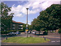
Traffic island near Birchington station
This traffic island is located at the junction of Grenham Road, Beach Avenue and Rossetti Road (named after the eponymous Dante Gabriel Rossetti, who is buried in the grounds of All Saints Church on Canterbury Road). This view was taken from the latter road looking towards Beach Avenue.
Image: © Robert Lamb
Taken: 22 Jun 2008
0.12 miles

7
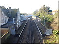
Birchington-on-Sea station
Looking up the line, it is about eight miles to the next station at Herne Bay.
The station was opened on 5th October 1863 by the Kent Coast Railway (KCR). The KCR was operated by the London, Chatham & Dover Railway (LCDR), which absorbed the KCR on 1st July 1871, and the station was renamed Birchington-on-Sea by the LCDR in October 1878.
Image: © Marathon
Taken: 23 Dec 2019
0.13 miles
8
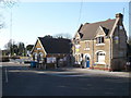
Birchington-on-Sea railway station
Viewed from the approach off Minnis Road. The right hand side of the building was a children's nursery and it now sports "To let" signs.
Image: © pam fray
Taken: 22 Mar 2009
0.14 miles
9
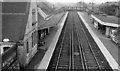
Birchington-on-Sea Station
View westwards, towards Faversham, Chatham and London; ex-LC&D London - Ramsgate main line (electrified 1959).
Image: © Ben Brooksbank
Taken: 16 Apr 1963
0.14 miles
10
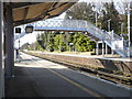
Platform 1 at Birchington-on-Sea station
Looking westwards towards Herne Bay.
Image: © pam fray
Taken: 22 Mar 2009
0.14 miles