IMAGES TAKEN NEAR TO
Potten Street, BIRCHINGTON, CT7 0QW
Introduction
This page details the photographs taken nearby to Potten Street, CT7 0QW by members of the Geograph project.
The Geograph project started in 2005 with the aim of publishing, organising and preserving representative images for every square kilometre of Great Britain, Ireland and the Isle of Man.

There are currently over 7.5m images from over14,400 individuals and you can help contribute to the project by visiting https://www.geograph.org.uk
Image Map (Loading...)


Getting Data...Please wait
Leaflet Map data © OpenStreetMap
Images are licensed for reuse under creativecommons.org/licenses/by-sa/2.0
Notes
- Clicking on the map will re-center to the selected point.
- The higher the marker number, the further away the image location is from the centre of the postcode.
Image Listing (15 Images Found)
Images are licensed for reuse under creativecommons.org/licenses/by-sa/2.0
Image
Details
Distance
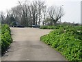
2
Farm track near Wagtail
This track leads from the A299 Dual Carriageway towards Down Barton.
It is also used by the Wantsum Walk (long distance path) leading towards St.Nicholas at Wade.
Image: © David Anstiss
Taken: 8 Aug 2010
0.05 miles
3
Junction of minor road with E bound carriageway of Thanet Way
Image: © Nick Smith
Taken: 31 Mar 2007
0.07 miles
4

Farm lane alongside A299
Looking west, on part of the Wanstum Way trail.
Image: © David Anstiss
Taken: 9 Oct 2008
0.07 miles
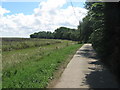
5
Farm road parallel to Thanet Way (A299)
The hill ahead is artificial, ramping up to a bridge over Thanet Way, which is to the left. This route is also used by the trail called the Wantsum Way to safely cross the dual carriageway.
Image: © Robin Webster
Taken: 20 Mar 2016
0.11 miles
6
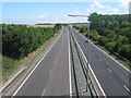
A299 Thanet Way Dual Carriageway
As seen from the bridge between Warehorn and Wagtail.
Looking eastwards towards Birchington.
Image: © David Anstiss
Taken: 8 Aug 2010
0.11 miles
7
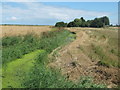
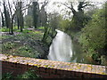
Warehorn Drain
A drain in Wade Marsh.
Seen from a farm road near Warehorn.
Image: © David Anstiss
Taken: 8 Aug 2010
0.12 miles
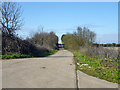
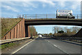
8

Bridge over the A299
This farm bridge leads between Wagtail and Warehorn on Potten Street Road.
It is also used by the Wantsum Walk (long distance path) heading from St. Nicholas at Wade towards Potten Street.
Image: © David Anstiss
Taken: 8 Aug 2010
0.13 miles
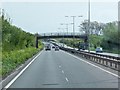
10
Bridge over A299 Thanet Way
A farm road crosses.
Image: © Robin Webster
Taken: 8 Feb 2018
0.13 miles