IMAGES TAKEN NEAR TO
Potten Street, BIRCHINGTON, CT7 0QR
Introduction
This page details the photographs taken nearby to Potten Street, CT7 0QR by members of the Geograph project.
The Geograph project started in 2005 with the aim of publishing, organising and preserving representative images for every square kilometre of Great Britain, Ireland and the Isle of Man.

There are currently over 7.5m images from over14,400 individuals and you can help contribute to the project by visiting https://www.geograph.org.uk
Image Map
Images are licensed for reuse under creativecommons.org/licenses/by-sa/2.0
Notes
- Clicking on the map will re-center to the selected point.
- The higher the marker number, the further away the image location is from the centre of the postcode.
Image Listing (14 Images Found)
Images are licensed for reuse under creativecommons.org/licenses/by-sa/2.0
Image
Details
Distance
1
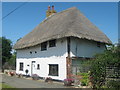
Nine Nail Cottage
Thatched Cottage on Potten Street.
Image: © David Anstiss
Taken: 8 Aug 2010
0.05 miles
2
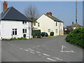
Houses on the road to Bartletts off Potten Street Road
Image: © Nick Smith
Taken: 31 Mar 2007
0.11 miles
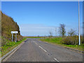
3
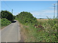
Potten Street Road
Road leading from the A299 Thanet Way Dual Carriageway towards Chambers Wall.
It is also used by the Wantsum Walk (long distance path).
Image: © David Anstiss
Taken: 8 Aug 2010
0.13 miles
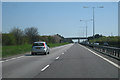
4
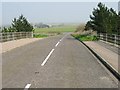
View N from the bridge over the Thanet Way
Image: © Nick Smith
Taken: 31 Mar 2007
0.18 miles
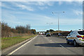
5
Turning off Thanet Way
Three left turns, one already done here, are needed to get from the eastbound Thanet Way back over it to St. Nicholas at Wade.
Image: © Robin Webster
Taken: 20 Mar 2016
0.20 miles
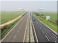
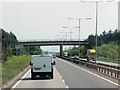
7
A299 Road, Thanet Way
Heading East bound.
Image: © Oast House Archive
Taken: 23 Apr 2010
0.21 miles
10

Turning off Potten Street Road to the Thanet Way
Image: © Nick Smith
Taken: 31 Mar 2007
0.23 miles