IMAGES TAKEN NEAR TO
Summer Road, BIRCHINGTON, CT7 0QE
Introduction
This page details the photographs taken nearby to Summer Road, CT7 0QE by members of the Geograph project.
The Geograph project started in 2005 with the aim of publishing, organising and preserving representative images for every square kilometre of Great Britain, Ireland and the Isle of Man.

There are currently over 7.5m images from over14,400 individuals and you can help contribute to the project by visiting https://www.geograph.org.uk
Image Map
Images are licensed for reuse under creativecommons.org/licenses/by-sa/2.0
Notes
- Clicking on the map will re-center to the selected point.
- The higher the marker number, the further away the image location is from the centre of the postcode.
Image Listing (10 Images Found)
Images are licensed for reuse under creativecommons.org/licenses/by-sa/2.0
Image
Details
Distance
1
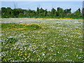
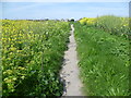
View from the Wantsum Walk
This field full of buttercups and daisies is seen from the Wantsum Walk as it reaches St Nicholas at Wade. The tower of St Nicholas Church can just be glimpsed above the trees in the centre of the picture.
Image: © Marathon
Taken: 4 May 2014
0.05 miles
2
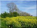
View from the Wantsum Way near St Nicholas at Wade
A pleasant tarmac footpath goes all the way from Sarre to St Nicholas at Wade, joining up with the Wantsum Walk along the way on its route down from Reculver. This attractive scene is seen as the outskirts of St Nicholas at Wade are reached. The oilseed rape may be an alien crop but it does brighten up the landscape while it lasts.
Image: © Marathon
Taken: 4 May 2014
0.09 miles
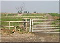
3
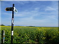
There is a bridleway along here
At least that is what the sign says but the field of oilseed rape will make it quite hard going. This bridleway leads off the Wantsum Walk on the outskirts of St Nicholas at Wade but only goes as far as Canterbury Road which is the busy A28. I cannot see how it would be very suitable for horses.
Image: © Marathon
Taken: 4 May 2014
0.15 miles
5
The Wantsum Walk approaches St Nicholas at Wade
This pleasant tarmac footpath goes all the way from Sarre to St Nicholas at Wade, joining up with the Wantsum Walk a short way behind on its way down from Reculver. As can be seen it is fairly open in a typical Thanet landscape. The outskirts of St Nicholas at Wade are directly ahead.
Image: © Marathon
Taken: 4 May 2014
0.17 miles
6
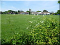
Cricket at St Nicholas at Wade
This typical village scene is on the recreation ground at St Nicholas at Wade. The tower of St Nicholas Church appears in the centre of the picture.
Image: © Marathon
Taken: 4 May 2014
0.20 miles
7
View across paddocks and farmland from Down Barton Road
Image: © Nick Smith
Taken: 31 Mar 2007
0.23 miles
8
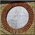
Inscription, School House, St. Nicholas at Wade
For the whole house, see Image .
Image: © Robin Webster
Taken: 20 Mar 2016
0.24 miles
9

The Bell Inn
Immediately opposite the Sun Inn.
Image: © Nick Smith
Taken: 3 Mar 2007
0.24 miles
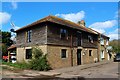
10
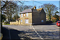
School House, St. Nicholas at Wade
A grade II listed building, 17th century, rebuilt 1796, as recorded on the circular inscribed stone at upper floor level - see Image .
Image: © Robin Webster
Taken: 20 Mar 2016
0.25 miles