IMAGES TAKEN NEAR TO
St. Nicholas At Wade, BIRCHINGTON, CT7 0PT
Introduction
This page details the photographs taken nearby to CT7 0PT by members of the Geograph project.
The Geograph project started in 2005 with the aim of publishing, organising and preserving representative images for every square kilometre of Great Britain, Ireland and the Isle of Man.

There are currently over 7.5m images from over14,400 individuals and you can help contribute to the project by visiting https://www.geograph.org.uk
Image Map
Images are licensed for reuse under creativecommons.org/licenses/by-sa/2.0
Notes
- Clicking on the map will re-center to the selected point.
- The higher the marker number, the further away the image location is from the centre of the postcode.
Image Listing (13 Images Found)
Images are licensed for reuse under creativecommons.org/licenses/by-sa/2.0
Image
Details
Distance
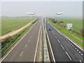
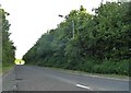
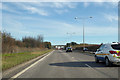
7
A299 Road, Thanet Way
Heading East bound.
Image: © Oast House Archive
Taken: 23 Apr 2010
0.19 miles
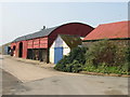
9
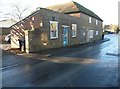
The Old Oak Bakery, Court Road
The single storey building attached to the main building has boarded up windows and therefore may be disused.
Image: © John Baker
Taken: 11 Dec 2013
0.22 miles