IMAGES TAKEN NEAR TO
St. Nicholas At Wade, BIRCHINGTON, CT7 0NL
Introduction
This page details the photographs taken nearby to CT7 0NL by members of the Geograph project.
The Geograph project started in 2005 with the aim of publishing, organising and preserving representative images for every square kilometre of Great Britain, Ireland and the Isle of Man.

There are currently over 7.5m images from over14,400 individuals and you can help contribute to the project by visiting https://www.geograph.org.uk
Image Map
Images are licensed for reuse under creativecommons.org/licenses/by-sa/2.0
Notes
- Clicking on the map will re-center to the selected point.
- The higher the marker number, the further away the image location is from the centre of the postcode.
Image Listing (11 Images Found)
Images are licensed for reuse under creativecommons.org/licenses/by-sa/2.0
Image
Details
Distance
1
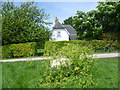
Belle Isle
This house is seen from the Wantsum Walk to the west of St Nicholas at Wade.
Image: © Marathon
Taken: 4 May 2014
0.01 miles
2
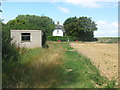
Belle Isle
Small cottage beside the Wade Marsh Stream. Seen from the bridleway from Down Barton leading past the cottage towards the A299 Thanet Way. Also used by the Wantsum Walk (long distance path). A farm track leads right towards St.Nicholas Court.
Image: © David Anstiss
Taken: 8 Aug 2010
0.01 miles
3
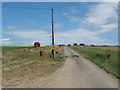
Farm track to St Nicholas Court
As seen from a bridleway near Belle Isle.
This farm track is also a public path.
Image: © David Anstiss
Taken: 8 Aug 2010
0.05 miles
4
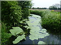
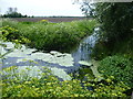
Wade Marsh Stream
This is the view from Snake Drove where it crosses Wade Marsh Stream.
Image: © Marathon
Taken: 4 May 2014
0.08 miles
5
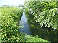
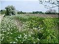
Waterways seen from Snake Drove
This is the view from Snake Drove where it crosses Wade Marsh Stream. The latter is to the left whereas the waterway to the right is an unnamed drainage ditch which is followed by the track named Snake Drove.
Image: © Marathon
Taken: 4 May 2014
0.09 miles
6
Track to Belle Isle
This track leads from St Nicholas at Wade to the house called Belle Isle which can be seen in the distance.
Image: © Marathon
Taken: 4 May 2014
0.12 miles
7
Wade Marsh Stream
This is the view from Snake Drove where it crosses Wade Marsh Stream.
Image: © Marathon
Taken: 4 May 2014
0.13 miles
8
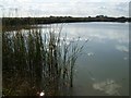
Reservoir at Belle Isle
Two reservoirs beside each other on the Wantsum Walk.
Very popular to anglers.
Image: © David Anstiss
Taken: 9 Oct 2008
0.18 miles
9
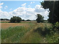
Alongside Snake Drove
This is the view alongside Snake Drove where it is followed by an unnamed drainage ditch. At the far side of the field on the right it meets Wade Marsh Stream and the Wantsum Walk.
Image: © Marathon
Taken: 4 May 2014
0.19 miles
10
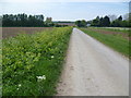
Wantsum Walk towards Down Barton
A bridleway leads from the A299 Thanet Way beside the Wade Marsh Stream towards the farm near St.Nicholas at Wade.
Sarre windmill can just be seen in the background.
Image: © David Anstiss
Taken: 8 Aug 2010
0.22 miles