IMAGES TAKEN NEAR TO
Canterbury Road, BIRCHINGTON, CT7 0LU
Introduction
This page details the photographs taken nearby to Canterbury Road, CT7 0LU by members of the Geograph project.
The Geograph project started in 2005 with the aim of publishing, organising and preserving representative images for every square kilometre of Great Britain, Ireland and the Isle of Man.

There are currently over 7.5m images from over14,400 individuals and you can help contribute to the project by visiting https://www.geograph.org.uk
Image Map
Images are licensed for reuse under creativecommons.org/licenses/by-sa/2.0
Notes
- Clicking on the map will re-center to the selected point.
- The higher the marker number, the further away the image location is from the centre of the postcode.
Image Listing (5 Images Found)
Images are licensed for reuse under creativecommons.org/licenses/by-sa/2.0
Image
Details
Distance
1
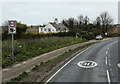
The White Cottage
Located beside the A28, Canterbury Road, close to Brooks End.
Image: © Martin Addison
Taken: 21 Mar 2015
0.01 miles
3
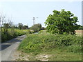
Upper Hale Lane
A byway north of the A28 west of Birchington.
Image: © Jonathan Billinger
Taken: 25 Apr 2007
0.06 miles
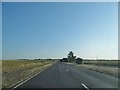
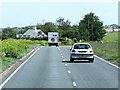
4
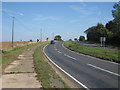
A28, Canterbury Road
Dual carriageway towards Birchington.
Image: © Oast House Archive
Taken: 21 Sep 2010
0.07 miles