IMAGES TAKEN NEAR TO
Margate Hill, BIRCHINGTON, CT7 0HS
Introduction
This page details the photographs taken nearby to Margate Hill, CT7 0HS by members of the Geograph project.
The Geograph project started in 2005 with the aim of publishing, organising and preserving representative images for every square kilometre of Great Britain, Ireland and the Isle of Man.

There are currently over 7.5m images from over14,400 individuals and you can help contribute to the project by visiting https://www.geograph.org.uk
Image Map
Images are licensed for reuse under creativecommons.org/licenses/by-sa/2.0
Notes
- Clicking on the map will re-center to the selected point.
- The higher the marker number, the further away the image location is from the centre of the postcode.
Image Listing (29 Images Found)
Images are licensed for reuse under creativecommons.org/licenses/by-sa/2.0
Image
Details
Distance
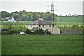
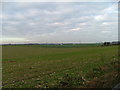
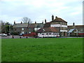
3
Lads Farm on Margate Hill seen from Manston Road
Image: © Nick Smith
Taken: 24 Mar 2008
0.02 miles
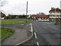
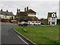
6
The Crown & Sceptre, Acol
Acol's sole hostelry began life as two separate farm dwellings as long ago as 1660. http://www.acolpc.kentparishes.gov.uk/default.cfm?pid=news&newsid=59
Image: © Nick Smith
Taken: 9 Mar 2008
0.14 miles
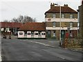
7
The Crown And Sceptre, Acol
On the junction of Margate Hill and Minster Road, from where the photo was taken.
Image: © Nick Smith
Taken: 9 Mar 2008
0.15 miles
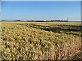
10
The Crown & Sceptre, Acol, from Crispe Road
Image: © Nick Smith
Taken: 9 Mar 2008
0.17 miles