IMAGES TAKEN NEAR TO
Park Road, BIRCHINGTON, CT7 0HA
Introduction
This page details the photographs taken nearby to Park Road, CT7 0HA by members of the Geograph project.
The Geograph project started in 2005 with the aim of publishing, organising and preserving representative images for every square kilometre of Great Britain, Ireland and the Isle of Man.

There are currently over 7.5m images from over14,400 individuals and you can help contribute to the project by visiting https://www.geograph.org.uk
Image Map
Images are licensed for reuse under creativecommons.org/licenses/by-sa/2.0
Notes
- Clicking on the map will re-center to the selected point.
- The higher the marker number, the further away the image location is from the centre of the postcode.
Image Listing (12 Images Found)
Images are licensed for reuse under creativecommons.org/licenses/by-sa/2.0
Image
Details
Distance
3

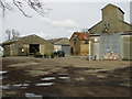
The Ploughman's Farm Shop
Converted farm shed on Park Road, part of Somali Farm.
Compare with Image, four years ago!
Image: © David Anstiss
Taken: 20 Feb 2011
0.04 miles
6
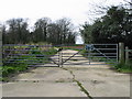
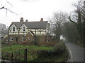
Gated private entrance to the Quex estate
Image: © Nick Smith
Taken: 24 Mar 2008
0.13 miles
7
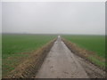
Bridleway to Minster Road
A track leads from Park Road, between two large fields to Close Cottages on the road.
Image: © David Anstiss
Taken: 20 Feb 2011
0.14 miles
8
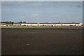
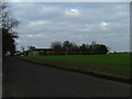
Fields off Park Road
Houses on Allen Avenue seen in distance.
Image: © Oast House Archive
Taken: 17 Sep 2010
0.18 miles
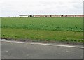
10
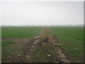
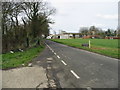
Track into fields beside Park Road.
This track leads to fields north of Park Road.
Image: © David Anstiss
Taken: 20 Feb 2011
0.20 miles