IMAGES TAKEN NEAR TO
Windmill View, CT7 0ER
Introduction
This page details the photographs taken nearby to Windmill View, CT7 0ER by members of the Geograph project.
The Geograph project started in 2005 with the aim of publishing, organising and preserving representative images for every square kilometre of Great Britain, Ireland and the Isle of Man.

There are currently over 7.5m images from over14,400 individuals and you can help contribute to the project by visiting https://www.geograph.org.uk
Image Map (Loading...)


Getting Data...Please wait
Leaflet Map data © OpenStreetMap
Images are licensed for reuse under creativecommons.org/licenses/by-sa/2.0
Notes
- Clicking on the map will re-center to the selected point.
- The higher the marker number, the further away the image location is from the centre of the postcode.
Image Listing (58 Images Found)
Images are licensed for reuse under creativecommons.org/licenses/by-sa/2.0
Image
Details
Distance
2
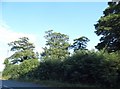
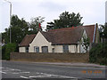
Bend, A28
The Sarre Windmill can just be seen through the trees.
Image: © N Chadwick
Taken: 12 Jan 2013
0.03 miles
4
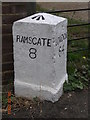
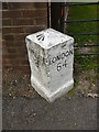
Old Milestone by the A253, Ramsgate Road, Sarre
Ramsgate limestone diamond by the A253, in parish of Sarre (Thanet District), Ramsgate Road, by Rose Bungalow, just West of old turnpike cottage and Sarre Windmill, between footpath and iron railings.
Inscription reads:-
: RAMSGATE / 8 : : LONDON / 64 :
Rivet benchmark on top.
Kent HER.
HER Number: TR 26 SE 200 https://www.heritagegateway.org.uk/Gateway/Results_Single.aspx?uid=MKE78171&resourceID=1005
Surveyed
Milestone Society National ID: KE_RGCY08
Image: © Alan Rosevear
Taken: 9 Aug 2004
0.03 miles
5
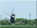
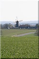
Sarre Windmill
Sarre Windmill is a Grade II listed (English Heritage ID:421289 http://www.imagesofengland.org.uk/details/default.aspx?pid=2&id=421289 Images of England) smock mill http://en.wikipedia.org/wiki/Smock_mill . It was built in 1820.
The mill was built in 1820 and raised in 1854. In 1861, a steam engine was installed Sarre mill becoming the first windmill in Kent to have a steam engine installed as auxiliary power. The mill fell into disuse in the 1940s and was used as an observation post during the Second World War. The mill It remained semi-derelict until it was restored as a working commercial mill in 1991. It was open to visitors and produced white and wholemeal flour and traditional rolled porridge oats until 2009.
Sometime after 2011, the mill was closed and the attached tearoom turned into a holiday cottage (http://www.nationalmillsweekend.co.uk/pages_wind/sarre.htm National Mills Weekend).
Image: © David Dixon
Taken: 16 May 2013
0.05 miles
6
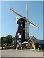
Sarre Mill
Kentish smock windmill built in 1820 and still working commercially.
Image: © John Smitten
Taken: 18 Aug 2005
0.05 miles
7
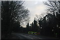
Old Toll House by Ramsgate Road, Sarre
Toll House in the parish of Sarre (Thanet District), Toll Gate Cottage, Ramsgate Road (A253), CT7 0LF.
Grade II listed.
List Entry Number: 1225055 https://historicengland.org.uk/listing/the-list/list-entry/1225055
Surveyed
Milestone Society National ID: KE.SAR
Image: © Alan Rosevear
Taken: 9 Aug 2004
0.05 miles
8
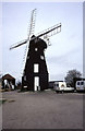
Sarre Windmill
A smock mill with a boat shaped cap and four patent sails (minus the shutters). This site was being used to store two dismantled stationary steam engines and was the real reason for my visit. These were later moved to Preston near Canterbury and one of them has been sold on.
Image: © Chris Allen
Taken: 19 Apr 1996
0.05 miles