IMAGES TAKEN NEAR TO
Brunswick Road, BIRCHINGTON, CT7 0EB
Introduction
This page details the photographs taken nearby to Brunswick Road, CT7 0EB by members of the Geograph project.
The Geograph project started in 2005 with the aim of publishing, organising and preserving representative images for every square kilometre of Great Britain, Ireland and the Isle of Man.

There are currently over 7.5m images from over14,400 individuals and you can help contribute to the project by visiting https://www.geograph.org.uk
Image Map
Images are licensed for reuse under creativecommons.org/licenses/by-sa/2.0
Notes
- Clicking on the map will re-center to the selected point.
- The higher the marker number, the further away the image location is from the centre of the postcode.
Image Listing (22 Images Found)
Images are licensed for reuse under creativecommons.org/licenses/by-sa/2.0
Image
Details
Distance
3
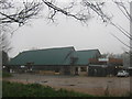
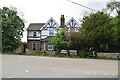
Quex Barn
Beside an access road into Quex Farm. The former farmers barn is being used as a farmers’ market and restaurant.
See http://www.quexbarn.com/ for more details about the barn restaurant.
Image: © David Anstiss
Taken: 20 Feb 2011
0.13 miles
4
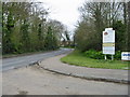
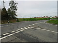
Park Lane and junction with Park Avenue
Park Avenue leads to the Quex Park Estate
Image: © Nick Smith
Taken: 24 Mar 2008
0.15 miles
5
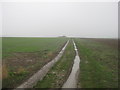
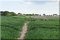
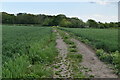
Track into the field near Acol Hill Farm
A track leads from the farm on Manston Road to a large field, then a footpath heads downhill towards the A28 Canterbury road near Brooks End.
Image: © David Anstiss
Taken: 20 Feb 2011
0.15 miles
6
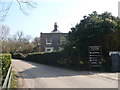
Quex Farm House, Quex Farm, Birchington
The lane is east of Park Lane and leads on to Quex House, Museum and Gardens.
Image: © pam fray
Taken: 22 Mar 2009
0.15 miles
8
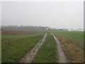
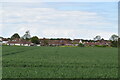
Track to Acol Hill Farm
This track is part of a footpath from the A28 Canterbury Road near Brooks End towards the farm on manston Road.
Image: © David Anstiss
Taken: 20 Feb 2011
0.16 miles