IMAGES TAKEN NEAR TO
Parish Close, BIRCHINGTON, CT7 0DR
Introduction
This page details the photographs taken nearby to Parish Close, CT7 0DR by members of the Geograph project.
The Geograph project started in 2005 with the aim of publishing, organising and preserving representative images for every square kilometre of Great Britain, Ireland and the Isle of Man.

There are currently over 7.5m images from over14,400 individuals and you can help contribute to the project by visiting https://www.geograph.org.uk
Image Map
Images are licensed for reuse under creativecommons.org/licenses/by-sa/2.0
Notes
- Clicking on the map will re-center to the selected point.
- The higher the marker number, the further away the image location is from the centre of the postcode.
Image Listing (43 Images Found)
Images are licensed for reuse under creativecommons.org/licenses/by-sa/2.0
Image
Details
Distance
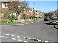
1
Parish Close
The road forms part of a housing development named Heritage Fields.
Image: © John Baker
Taken: 2 May 2022
0.03 miles
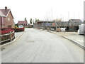
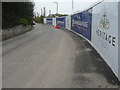
2

Construction site, Manor Road
Planning permission has been granted by Thanet District Council under application number F/TH/15/0770 for the “erection of 17 dwellings with associated parking and access from Manor Road”.
Sunningdale House Developments Ltd https://www.sunningdalehouse.co.uk/our-developments/heritage-fields-margate-new-homes-in-kent has given the name Heritage Fields to this development.
This image of the Image shows that the main entrance to the site is just beyond the nearer lamppost.
Image: © John Baker
Taken: 6 Jan 2019
0.04 miles
3
Construction site, Manor Road
Planning permission has been granted by Thanet District Council under application number F/TH/15/0770 for the “erection of 17 dwellings with associated parking and access from Manor Road”.
Sunningdale House Developments Ltd https://www.sunningdalehouse.co.uk/our-developments/heritage-fields-margate-new-homes-in-kent has given the name Heritage Fields to this development.
Image: © John Baker
Taken: 6 Jan 2019
0.04 miles
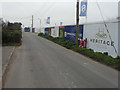
4
Manor Road
Taking a right turn after the keep left road sign leads one into Image, which in January 2019 was the entrance to the Image of Heritage Fields.
Image: © John Baker
Taken: 2 May 2022
0.05 miles
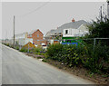
5
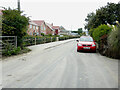
Manor Road
The house, under construction, forms part of a development called Heritage Fields. The gate would once have given access to agricultural land.
Image: © John Baker
Taken: 18 Sep 2022
0.05 miles
6
Construction site, Manor Road
Planning permission has been granted by Thanet District Council under application number F/TH/15/0770 for the “erection of 17 dwellings with associated parking and access from Manor Road”.
Sunningdale House Developments Ltd https://www.sunningdalehouse.co.uk/our-developments/heritage-fields-margate-new-homes-in-kent has given the name Heritage Fields to this development.
This image of the Image shows this section of hoarding is located, just beyond the further electricity pole.
Image: © John Baker
Taken: 6 Jan 2019
0.05 miles
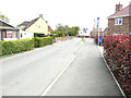
7
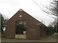
Manor Hall, St. Nicholas at Wade
Church hall built in 1964, on Manor Road.
Image: © David Anstiss
Taken: 6 Feb 2011
0.09 miles
8
Manor Road
The houses, under construction, form part of a development called Heritage Fields.
Image: © John Baker
Taken: 18 Sep 2022
0.09 miles
10
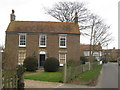
Myrtle Villa, St. Nicholas at Wade
House on Manor Road.
Image: © David Anstiss
Taken: 6 Feb 2011
0.12 miles