IMAGES TAKEN NEAR TO
Clarence Street, HERNE BAY, CT6 8TS
Introduction
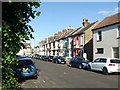
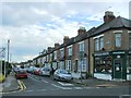
This page details the photographs taken nearby to Clarence Street, CT6 8TS by members of the Geograph project.
The Geograph project started in 2005 with the aim of publishing, organising and preserving representative images for every square kilometre of Great Britain, Ireland and the Isle of Man.

There are currently over 7.5m images from over14,400 individuals and you can help contribute to the project by visiting https://www.geograph.org.uk
Image Map
Images are licensed for reuse under creativecommons.org/licenses/by-sa/2.0
Notes
- Clicking on the map will re-center to the selected point.
- The higher the marker number, the further away the image location is from the centre of the postcode.
Image Listing (303 Images Found)
Images are licensed for reuse under creativecommons.org/licenses/by-sa/2.0
Image
Details
Distance
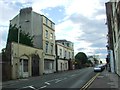
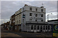
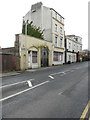
5
The Four Fathoms Pub, Herne Bay
On junction of 2 High Street and Station Road.
Image: © David Anstiss
Taken: 6 Dec 2008
0.05 miles
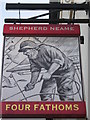
8
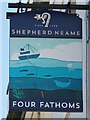
Four Fathoms sign
Sign for Four Fathoms, a Shepherd Neame pub on High Street.
Image: © Oast House Archive
Taken: 22 Apr 2018
0.05 miles
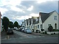
9
White Horse, 13, Avenue Road
The http://www.dover-kent.com/2014-project-a/White-Horse-Herne-Bay.html
confirms the name of this public house, which appears to be closed.
Image: © John Baker
Taken: 25 Jan 2016
0.06 miles