IMAGES TAKEN NEAR TO
Montague Street, HERNE BAY, CT6 8TJ
Introduction
This page details the photographs taken nearby to Montague Street, CT6 8TJ by members of the Geograph project.
The Geograph project started in 2005 with the aim of publishing, organising and preserving representative images for every square kilometre of Great Britain, Ireland and the Isle of Man.

There are currently over 7.5m images from over14,400 individuals and you can help contribute to the project by visiting https://www.geograph.org.uk
Image Map
Images are licensed for reuse under creativecommons.org/licenses/by-sa/2.0
Notes
- Clicking on the map will re-center to the selected point.
- The higher the marker number, the further away the image location is from the centre of the postcode.
Image Listing (147 Images Found)
Images are licensed for reuse under creativecommons.org/licenses/by-sa/2.0
Image
Details
Distance
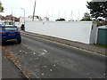
1

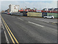
Part of The Elements housing development
This part of the development is located in Clarence Road but the road leading into it also has the same name. The road sign, on its right, indicates that it leads to Carpenters Court and Founders View. Carpenters Court is the taller building beyond the row of houses known as Millers Rest https://elements-hernebay.co.uk/page/overview
Image: © John Baker
Taken: 26 May 2019
0.03 miles
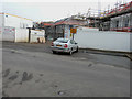
2
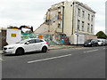
Building site, 41 Avenue Road
Seen from Clarence Road, planning permission was granted by Canterbury City Council under application numbers CA//15/02786 & CA//15/02787 for the “retention of listed building and reinstatement from school back to dwelling. Remainder of school to be demolished for residential development comprising of 17 apartments, 5 semi-detached units and 8 townhouses”.
It is grade II listed with the original portion of the building being a house of about 1820. There are modern school additions to the east and west. It used to be known as La Sainte Union Convent School http://www.britishlistedbuildings.co.uk/101336849-la-sainte-union-convent-school-canterbury#.VsN23cLcvcc
This image shows Image before demolition commenced, which has reduced the building to the part which is being retained. A small fragment of this part can be seen to the right of the lamppost, in the distance.
The building site will become part of The Elements housing development https://elements-hernebay.co.uk/page/overview
Image: © John Baker
Taken: 10 Sep 2017
0.03 miles
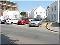
3
The Elements housing development
Viewed from Clarence Road, the houses, under construction, are to be named Millers Rest https://elements-hernebay.co.uk/page/overview
Planning permission was granted by Canterbury City Council under application numbers CA//15/02786 & CA//15/02787 for the “retention of listed building and reinstatement from school back to dwelling. Remainder of school to be demolished for residential development comprising of 17 apartments, 5 semi-detached units and 8 townhouses”.
Image: © John Baker
Taken: 11 Mar 2018
0.04 miles
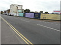
4
The Elements housing development
Viewed from Clarence Road, the white-painted houses are to be named Millers Rest while the taller house, at the far end, is to be named Carpenters Court. The house under construction, on the left, is to be named Founders View
https://elements-hernebay.co.uk/page/overview
Image: © John Baker
Taken: 1 Jul 2018
0.04 miles
5
The Elements housing development, 41 Avenue Road
Planning permission was granted by Canterbury City Council under application numbers CA//15/02786 & CA//15/02787 for the “retention of listed building and reinstatement from school back to dwelling. Remainder of school to be demolished for residential development comprising of 17 apartments, 5 semi-detached units and 8 townhouses”.
It is grade II listed with the original portion of the building being a house of about 1820. There are modern school additions to the east and west. It used to be known as La Sainte Union Convent School http://www.britishlistedbuildings.co.uk/101336849-la-sainte-union-convent-school-canterbury#.VsN23cLcvcc
This image shows Image before demolition commenced, which has reduced the
building to the part which is being retained, as seen here.
This https://elements-hernebay.co.uk/page/overview relates to the housing development.
Image: © John Baker
Taken: 10 Sep 2017
0.05 miles
6
The Elements housing development, Avenue Road
This image taken in September 2017, shows Image as it was then.
Planning permission was granted by Canterbury City Council under application numbers CA//15/02786 & CA//15/02787 for the “retention of listed building and reinstatement from school back to dwelling. Remainder of school to be demolished for residential development comprising of 17 apartments, 5 semi-detached units and 8 townhouses”.
It is grade II listed with the original portion of the building being a house of about 1820. There are modern school additions to the east and west. It used to be known as La Sainte Union Convent School https://www.britishlistedbuildings.co.uk/101336849-la-sainte-union-convent-school-canterbury#.VsN23cLcvcc
This https://elements-hernebay.co.uk/page/overview relates to the housing development.
Image: © John Baker
Taken: 11 Mar 2018
0.06 miles
7
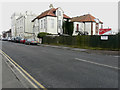
St Philip Howard Roman Catholic Primary School, 41 Avenue Road
Planning permission has been granted by Canterbury City Council under application numbers CA//15/02786 & CA//15/02787 for the “retention of listed building and reinstatement from school back to dwelling. Remainder of school to be demolished for residential development comprising of 17 apartments, 5 semi-detached units and 8 townhouses”.
It is grade II listed with the original portion of the building being a house of about 1820. There are modern school additions to the east and west. It used to be known as La Sainte Union Convent School
http://www.britishlistedbuildings.co.uk/en-170659-la-sainte-union-convent-school-kent#.VsN23cLcvcc
Image: © John Baker
Taken: 25 Jan 2016
0.06 miles
8
Building site, 41 Avenue Road
Planning permission was granted by Canterbury City Council under application numbers CA//15/02786 & CA//15/02787 for the “retention of listed building and reinstatement from school back to dwelling. Remainder of school to be demolished for residential development comprising of 17 apartments, 5 semi-detached units and 8 townhouses”.
It is grade II listed with the original portion of the building being a house of about 1820. There are modern school additions to the east and west. It used to be known as La Sainte Union Convent School http://www.britishlistedbuildings.co.uk/101336849-la-sainte-union-convent-school-canterbury#.VsN23cLcvcc
This image shows Image before demolition commenced, which has reduced the building to the part which is being retained, as seen here.
The building site will become part of The Elements housing development https://elements-hernebay.co.uk/page/overview
Image: © John Baker
Taken: 10 Sep 2017
0.06 miles
9
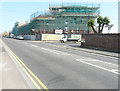
The Elements housing development
Located on the corner of Avenue Road and Clarence Road, the building encased in scaffolding and turquoise safety netting in Clarence Road is to be named Founders View and the buildings encased in scaffolding and turquoise safety netting in Avenue Road are to be named Merchants Row https://elements-hernebay.co.uk/page/overview
Image: © John Baker
Taken: 1 Jul 2018
0.06 miles
10
The Elements housing development
Located on the corner of Avenue Road and Clarence Road, Founders View is the tall building in Clarence Road, while Millers Rest are the white painted houses, to its right. Merchants Row is the building with dormer windows in Avenue Road https://elements-hernebay.co.uk/page/overview
This was Image in July 2018.
Image: © John Baker
Taken: 26 May 2019
0.06 miles