IMAGES TAKEN NEAR TO
Albany Drive, HERNE BAY, CT6 8PR
Introduction
This page details the photographs taken nearby to Albany Drive, CT6 8PR by members of the Geograph project.
The Geograph project started in 2005 with the aim of publishing, organising and preserving representative images for every square kilometre of Great Britain, Ireland and the Isle of Man.

There are currently over 7.5m images from over14,400 individuals and you can help contribute to the project by visiting https://www.geograph.org.uk
Image Map
Images are licensed for reuse under creativecommons.org/licenses/by-sa/2.0
Notes
- Clicking on the map will re-center to the selected point.
- The higher the marker number, the further away the image location is from the centre of the postcode.
Image Listing (58 Images Found)
Images are licensed for reuse under creativecommons.org/licenses/by-sa/2.0
Image
Details
Distance
8
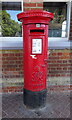
George VI postbox, Herne Bay Railway Station
Postbox No. CT6 49.
See Image] forc context.
Image: © JThomas
Taken: 22 Jun 2022
0.09 miles
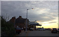
9
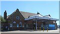
Herne Bay Railway Station
Showing position of Postbox No. CT6 49.
See Image] for postbox.
Image: © JThomas
Taken: 22 Jun 2022
0.09 miles
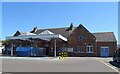
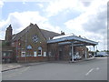
10
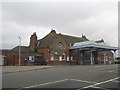
Herne Bay Railway Station
On the Circus. On the railway between London and Ramsgate.
Image: © David Anstiss
Taken: 8 Aug 2010
0.10 miles