IMAGES TAKEN NEAR TO
The Broadway, HERNE BAY, CT6 8EX
Introduction
This page details the photographs taken nearby to The Broadway, CT6 8EX by members of the Geograph project.
The Geograph project started in 2005 with the aim of publishing, organising and preserving representative images for every square kilometre of Great Britain, Ireland and the Isle of Man.

There are currently over 7.5m images from over14,400 individuals and you can help contribute to the project by visiting https://www.geograph.org.uk
Image Map
Images are licensed for reuse under creativecommons.org/licenses/by-sa/2.0
Notes
- Clicking on the map will re-center to the selected point.
- The higher the marker number, the further away the image location is from the centre of the postcode.
Image Listing (81 Images Found)
Images are licensed for reuse under creativecommons.org/licenses/by-sa/2.0
Image
Details
Distance
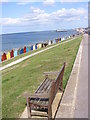
6
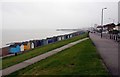
Beach huts and grass slope by Western Esplanade
Image: © Steve Daniels
Taken: 11 Oct 2012
0.05 miles
7
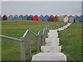
Steps from the Western Esplanade to the beach huts
This is seen between Hampton and Herne Bay.
Image: © pam fray
Taken: 17 Jan 2009
0.06 miles
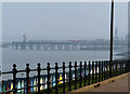
8
Herne Bay View
Looking east towards the Pier form the Western Esplanade.
Image: © Gordon Griffiths
Taken: 23 Jul 2009
0.06 miles
9
View from Western Esplanade
Towards Herne Bay Pier
Image: © Chris Gunns
Taken: 10 Mar 2016
0.06 miles