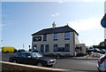
IMAGES TAKEN NEAR TO
Western Esplanade, HERNE BAY, CT6 8DN
Introduction
This page details the photographs taken nearby to Western Esplanade, CT6 8DN by members of the Geograph project.
The Geograph project started in 2005 with the aim of publishing, organising and preserving representative images for every square kilometre of Great Britain, Ireland and the Isle of Man.

There are currently over 7.5m images from over14,400 individuals and you can help contribute to the project by visiting https://www.geograph.org.uk
Image Map
Images are licensed for reuse under creativecommons.org/licenses/by-sa/2.0
Notes
- Clicking on the map will re-center to the selected point.
- The higher the marker number, the further away the image location is from the centre of the postcode.
Image Listing (135 Images Found)
Images are licensed for reuse under creativecommons.org/licenses/by-sa/2.0
Image
Details
Distance
1
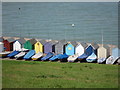
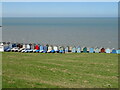
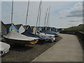
Boats and beach huts
A row of sailing boats, and beach huts by the Saxo Shore Way next to Herne Bay Amateur Rowing Club.
Image: © Oast House Archive
Taken: 31 May 2011
0.06 miles
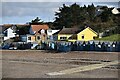
3
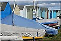
Boats and beach huts at Hampton
This is the landward side of the row of beach huts, adjacent to the coastal path.
Image: © David Martin
Taken: 18 Mar 2023
0.06 miles