IMAGES TAKEN NEAR TO
High View Avenue, HERNE BAY, CT6 8DG
Introduction
This page details the photographs taken nearby to High View Avenue, CT6 8DG by members of the Geograph project.
The Geograph project started in 2005 with the aim of publishing, organising and preserving representative images for every square kilometre of Great Britain, Ireland and the Isle of Man.

There are currently over 7.5m images from over14,400 individuals and you can help contribute to the project by visiting https://www.geograph.org.uk
Image Map
Images are licensed for reuse under creativecommons.org/licenses/by-sa/2.0
Notes
- Clicking on the map will re-center to the selected point.
- The higher the marker number, the further away the image location is from the centre of the postcode.
Image Listing (139 Images Found)
Images are licensed for reuse under creativecommons.org/licenses/by-sa/2.0
Image
Details
Distance
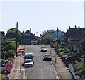
1
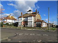
The not so grand Burford House in Grand Drive, Herne Bay
Looking north-eastward. The Cupola was once used by Ordnance Survey as one of their Benchmark (Intersected Station) locations. http://trigpointing.uk/trig/9438
Image: © Peter Wood
Taken: 16 Feb 2016
0.05 miles
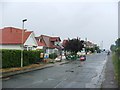
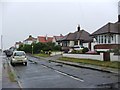
4
Contemporary redevelopment at Hampton Pier Avenue
Image: © Oast House Archive
Taken: 22 Apr 2018
0.07 miles
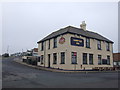
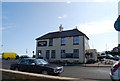
10
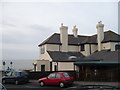
Hampton Inn, a Shepherd Neame pub by Hampton Pier
Image: © pam fray
Taken: 17 Jan 2009
0.09 miles