IMAGES TAKEN NEAR TO
Whitstable Road, HERNE BAY, CT6 8BJ
Introduction
This page details the photographs taken nearby to Whitstable Road, CT6 8BJ by members of the Geograph project.
The Geograph project started in 2005 with the aim of publishing, organising and preserving representative images for every square kilometre of Great Britain, Ireland and the Isle of Man.

There are currently over 7.5m images from over14,400 individuals and you can help contribute to the project by visiting https://www.geograph.org.uk
Image Map
Images are licensed for reuse under creativecommons.org/licenses/by-sa/2.0
Notes
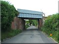
- Clicking on the map will re-center to the selected point.
- The higher the marker number, the further away the image location is from the centre of the postcode.
Image Listing (11 Images Found)
Images are licensed for reuse under creativecommons.org/licenses/by-sa/2.0
Image
Details
Distance
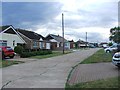
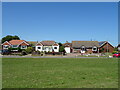
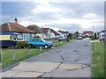
2
Hampton Close
An estate of semi-detached houses off Whitstable Road.
Image: © Oast House Archive
Taken: 31 May 2011
0.06 miles
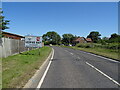
3
Whitstable Road (B2205)
GN59 EWR, Scania N230UD with Alexander Enviro400 bodywork in Stagecoach in East Kent livery, on Whitstable Road near Studd Hill.
Image: © David Dixon
Taken: 16 May 2013
0.10 miles
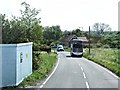
7
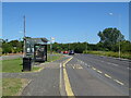
Bus stop and shelter on Whitstable Road (B2205)
Image: © JThomas
Taken: 22 Jun 2022
0.15 miles
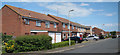
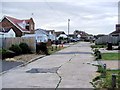
9
Thornden Close, Greenhill
Formerly Thornden Wood Road, now used as a footpath.
Image: © Chris Whippet
Taken: 24 Jun 2015
0.17 miles