IMAGES TAKEN NEAR TO
Austin Avenue, HERNE BAY, CT6 8BA
Introduction
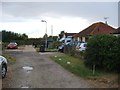
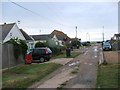
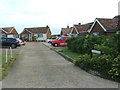
This page details the photographs taken nearby to Austin Avenue, CT6 8BA by members of the Geograph project.
The Geograph project started in 2005 with the aim of publishing, organising and preserving representative images for every square kilometre of Great Britain, Ireland and the Isle of Man.

There are currently over 7.5m images from over14,400 individuals and you can help contribute to the project by visiting https://www.geograph.org.uk
Image Map
Images are licensed for reuse under creativecommons.org/licenses/by-sa/2.0
Notes
- Clicking on the map will re-center to the selected point.
- The higher the marker number, the further away the image location is from the centre of the postcode.
Image Listing (34 Images Found)
Images are licensed for reuse under creativecommons.org/licenses/by-sa/2.0
Image
Details
Distance
8
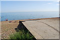
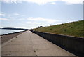
Beach between Swalecliffe and Studd Hill
The beach here is a mixture of sand and shingle. Hampton can be seen in the distance, its houses rising up the hill, whilst Hampton Pier is to the left. Left of this and stranded out to sea is the end of the old Herne Bay Pier which was once the second longest in the country.
Image: © Marathon
Taken: 17 Sep 2010
0.08 miles