IMAGES TAKEN NEAR TO
Steed Close, HERNE BAY, CT6 7TQ
Introduction
This page details the photographs taken nearby to Steed Close, CT6 7TQ by members of the Geograph project.
The Geograph project started in 2005 with the aim of publishing, organising and preserving representative images for every square kilometre of Great Britain, Ireland and the Isle of Man.

There are currently over 7.5m images from over14,400 individuals and you can help contribute to the project by visiting https://www.geograph.org.uk
Image Map (Loading...)


Getting Data...Please wait
Leaflet Map data © OpenStreetMap
Images are licensed for reuse under creativecommons.org/licenses/by-sa/2.0
Notes
- Clicking on the map will re-center to the selected point.
- The higher the marker number, the further away the image location is from the centre of the postcode.
Image Listing (64 Images Found)
Images are licensed for reuse under creativecommons.org/licenses/by-sa/2.0
Image
Details
Distance
3
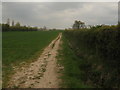
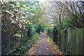
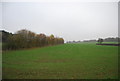
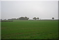
Footpath to Hawe Shave
This path beside a hedge leads from a path beside Herne School. It leads to a small triangle of woodland near a bridleway. In the background is Hawe Farm.
Image: © David Anstiss
Taken: 25 Apr 2010
0.12 miles
7
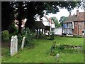
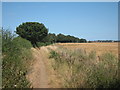
View from St Martin's Church, Herne, Kent
Image: © John Salmon
Taken: 19 Jun 2008
0.17 miles