IMAGES TAKEN NEAR TO
Lytham Avenue, HERNE BAY, CT6 7TP
Introduction
This page details the photographs taken nearby to Lytham Avenue, CT6 7TP by members of the Geograph project.
The Geograph project started in 2005 with the aim of publishing, organising and preserving representative images for every square kilometre of Great Britain, Ireland and the Isle of Man.

There are currently over 7.5m images from over14,400 individuals and you can help contribute to the project by visiting https://www.geograph.org.uk
Image Map
Images are licensed for reuse under creativecommons.org/licenses/by-sa/2.0
Notes
- Clicking on the map will re-center to the selected point.
- The higher the marker number, the further away the image location is from the centre of the postcode.
Image Listing (7 Images Found)
Images are licensed for reuse under creativecommons.org/licenses/by-sa/2.0
Image
Details
Distance
1
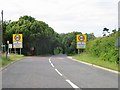
What speed limit, I didn't see a sign!
Entering Greenhill from the South
Image: © Nick Smith
Taken: 26 Jun 2007
0.10 miles
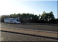
2
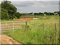
New road works?
Some new road seems to be under construction, just off the Bullockstone Road outside Greenhill.
Image: © Nick Smith
Taken: 26 Jun 2007
0.10 miles
3
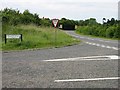
Junction of Owl's Hatch Road (North) with Bullockstone Road
Owl's Hatch Road is gated with 'no vehicle access' sign.
Image: © Nick Smith
Taken: 26 Jun 2007
0.15 miles
4
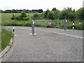
Owl's Hatch Road (North) - no vehicle access
Both Owl's Hatch Road N and S follow the new Thanet Way, this one (N) doesn't appear to go anywhere.
Image: © Nick Smith
Taken: 26 Jun 2007
0.16 miles
5
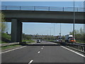
Bridge Over A299, Thanet Way
Carrying Bullockstone Road.
Image: © Oast House Archive
Taken: 23 Apr 2010
0.22 miles
7
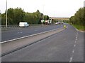
The A299, Thanet Way
The A299, Thanet Way viewed from a layby near Greenhill.
Image: © Philip Halling
Taken: 12 Aug 2021
0.24 miles