IMAGES TAKEN NEAR TO
Kingfisher Court, HERNE BAY, CT6 7PL
Introduction
This page details the photographs taken nearby to Kingfisher Court, CT6 7PL by members of the Geograph project.
The Geograph project started in 2005 with the aim of publishing, organising and preserving representative images for every square kilometre of Great Britain, Ireland and the Isle of Man.

There are currently over 7.5m images from over14,400 individuals and you can help contribute to the project by visiting https://www.geograph.org.uk
Image Map
Images are licensed for reuse under creativecommons.org/licenses/by-sa/2.0
Notes
- Clicking on the map will re-center to the selected point.
- The higher the marker number, the further away the image location is from the centre of the postcode.
Image Listing (40 Images Found)
Images are licensed for reuse under creativecommons.org/licenses/by-sa/2.0
Image
Details
Distance
2

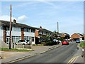
New Entrance to Herne Bay High School
This specialist school and sports college is on Bullockstone Road.
It has had a new entrance and other redevelopment works built by Provain.
See http://www.hernebayhigh.kent.sch.uk/ for more about the school.
See http://www.brett-construction.co.uk/hbhs_bsf.htm for more about the redevelopment works.
Image: © David Anstiss
Taken: 25 Apr 2010
0.08 miles
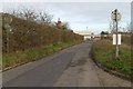
5
Traffic Lights on Cobblers Bridge
These traffic lights are on the narrow single lane leading over the railway. The lane leads from Herne Bay towards a group of warehouses and the A2990 Thanet Way. Before the road bridge, the road was Cobblers Bridge Road, afterward is Eddington Lane.
The bridge passes over the Chestfield to Herne bay Railway Line.
Image: © David Anstiss
Taken: 1 Aug 2009
0.10 miles
6

Entrance to Herne Bay High School
As seen from Bullockstone Road.
Image: © David Anstiss
Taken: 25 Apr 2010
0.13 miles
7

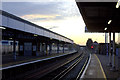
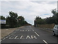
Railway seen from Greenhill Bridge Road
The route between Faversham and Whitstable was opened by the Margate Railway on 1st August 1860, and was extended to Herne Bay on 13th July 1861. Herne Bay station is just around the bend in the distance.
Image: © Marathon
Taken: 26 Aug 2023
0.14 miles