IMAGES TAKEN NEAR TO
Canterbury Road, HERNE BAY, CT6 7HB
Introduction
This page details the photographs taken nearby to Canterbury Road, CT6 7HB by members of the Geograph project.
The Geograph project started in 2005 with the aim of publishing, organising and preserving representative images for every square kilometre of Great Britain, Ireland and the Isle of Man.

There are currently over 7.5m images from over14,400 individuals and you can help contribute to the project by visiting https://www.geograph.org.uk
Image Map
Images are licensed for reuse under creativecommons.org/licenses/by-sa/2.0
Notes
- Clicking on the map will re-center to the selected point.
- The higher the marker number, the further away the image location is from the centre of the postcode.
Image Listing (16 Images Found)
Images are licensed for reuse under creativecommons.org/licenses/by-sa/2.0
Image
Details
Distance
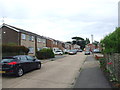
2
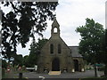
Chapel of Rest in Herne bay Cemetery
In the Cemetery on the A291 Canterbury Road, on the outskirts of Herne Bay.
Image: © David Anstiss
Taken: 1 Aug 2009
0.10 miles
6
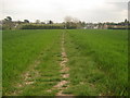
Footpath to Lower Herne Road
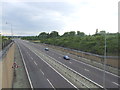
This path leads from Mandarin Lane, Greenhill, through Herne Bay Golf Course, then under A299 dual carriageway towards Lower Herne.
Image: © David Anstiss
Taken: 25 Apr 2010
0.18 miles
8
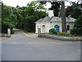
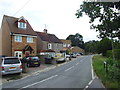
Entrance and gatehouse to Strode Park
The Strode Park Foundation (est. 1946) is one of the largest resource centres in Kent for people with physical disabilities. It is located in 14 acres of beautiful grounds in the village of Herne, Kent.
Image: © Nick Smith
Taken: 26 Jun 2007
0.21 miles
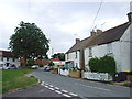
10

Wheat field by Lower Herne Road
Looking to Herne, and Herne Windmill.
Image: © Oast House Archive
Taken: 18 Aug 2012
0.22 miles