IMAGES TAKEN NEAR TO
Mount View Road, HERNE BAY, CT6 7DJ
Introduction
This page details the photographs taken nearby to Mount View Road, CT6 7DJ by members of the Geograph project.
The Geograph project started in 2005 with the aim of publishing, organising and preserving representative images for every square kilometre of Great Britain, Ireland and the Isle of Man.

There are currently over 7.5m images from over14,400 individuals and you can help contribute to the project by visiting https://www.geograph.org.uk
Image Map
Images are licensed for reuse under creativecommons.org/licenses/by-sa/2.0
Notes
- Clicking on the map will re-center to the selected point.
- The higher the marker number, the further away the image location is from the centre of the postcode.
Image Listing (35 Images Found)
Images are licensed for reuse under creativecommons.org/licenses/by-sa/2.0
Image
Details
Distance
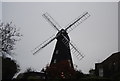
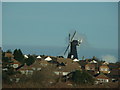
2
Herne windmill
This smock mill is open on Sundays in the summer.
Image: © Jim Woodward-Nutt
Taken: 7 May 2005
0.05 miles
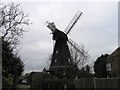
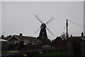
5
Herne Mill, viewed from the A299 eastbound
Herne Mill sits at the top of the hill off Canterbury Road near to Herne Village, and can be seen from the A299 as it rounds the corner and approaches the turn-off for the A2990 (its older counterpart) and the A291 Canterbury Road. Whether it is still operational or not, however, is another question, as I have never seen it turning. The wind propeller, however, is evidently working, as the windmill was turned in the opposite direction when I last passed here. View taken from the A299 eastbound (towards Margate) looking east.
Image: © Robert Lamb
Taken: 14 Feb 2009
0.05 miles
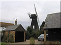
6
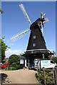
Herne windmill
This magnificent smock mill is open to visitors in the summer season
Image: © Jim Woodward-Nutt
Taken: 7 May 2005
0.06 miles
9
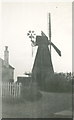
Herne Mill 1938
This picture has been identified as Herne on account of the chimney on the adjacent house. It was taken by a lady from a very poor Northamptonshire family who, as a girl, was invited with her sister to seaside holidays in Dover by a relative (an uncle who had been blinded in WW1). We think she must have arrived at Herne by train, since the station is nearby. She was 18 years old in 1938.
Herne Mill is a Kentish smock windmill dating from 1789. It is Grade I listed and is owned by Kent County Council and cared for by the Friends of Herne Mill.
The latest in a long line of mills which have occupied the site for centuries, the windmill is a local landmark on the skyline above the ancient village of Herne in Kent. It can be seen from the A299 Thanet Way, which passes nearby; from the Thames Estuary where it is a ‘sea mark’ and from the countryside around.
See http://www.herne-mill.btik.com/ and http://herne-mill.btck.co.uk/TheFriendsofHerneMill. The photo has been sent to the latter for inclusion on their website, which also gives a detailed history of the windmill.
The photo has
Image: © Celia Fossey
Taken: Unknown
0.06 miles
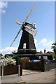
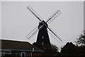
10
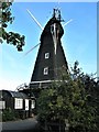
Herne Windmill
The octagonal Herne Mill was probably built in 1789, a date which is carved into a post inside the mill. It is a Grade I listed building. https://britishlistedbuildings.co.uk/101084984-herne-windmill-herne-and-broomfield#.W6eoYfZFw5s
Image: © G Laird
Taken: 14 Sep 2018
0.07 miles