IMAGES TAKEN NEAR TO
Keat Farm Close, HERNE BAY, CT6 6SL
Introduction
This page details the photographs taken nearby to Keat Farm Close, CT6 6SL by members of the Geograph project.
The Geograph project started in 2005 with the aim of publishing, organising and preserving representative images for every square kilometre of Great Britain, Ireland and the Isle of Man.

There are currently over 7.5m images from over14,400 individuals and you can help contribute to the project by visiting https://www.geograph.org.uk
Image Map
Images are licensed for reuse under creativecommons.org/licenses/by-sa/2.0
Notes
- Clicking on the map will re-center to the selected point.
- The higher the marker number, the further away the image location is from the centre of the postcode.
Image Listing (20 Images Found)
Images are licensed for reuse under creativecommons.org/licenses/by-sa/2.0
Image
Details
Distance
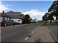
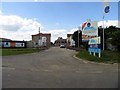
1
Hillborough Caravan Site today
This is what Hillborough Caravan Site looks like today - a housing development with a new roundabout on Reculver Road. It is almost unrecognizable from when my family and I used to spend our summer holidays here from the 70s right through to the 90s. The access road to the site is now a council-owned road called Sanderling Road and has several cul-de-sacs leading off it, whereas of course when the caravan site was opened it was simply a privately owned road and lead to a circular road surrounded by the caravans. The caravan site closed in 1998, probably because of lack of economy, as caravanning as a holiday activity has declined rapidly. I reckon even today it would've had problems in surviving, as I don't think many people could afford the rent for caravanning in these times of the credit crunch. View taken looking south-southeast towards Hillborough.
Image: © Robert Lamb
Taken: 14 Dec 2008
0.07 miles
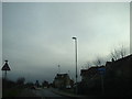
3
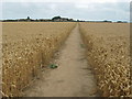
Wantsum Walk to Bishopstone
The long distance path leads from Reculver Road, towards Bishopstone Lane.
Image: © David Anstiss
Taken: 8 Aug 2010
0.16 miles

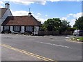
6
![Hillborough buildings [5]](https://s0.geograph.org.uk/geophotos/07/05/84/7058444_52b8a8a5_120x120.jpg)
Hillborough buildings [5]
Forge House, Reculver Lane, is an 18th century building. Constructed of rendered brick under a tile roof. There is a modern extension on the right. Listed, grade II, with details at: https://historicengland.org.uk/listing/the-list/list-entry/1084988
Hillborough is a suburb of the town of Herne Bay, a seaside town on the Thames Estuary, some 6 miles north of Canterbury and about 4 miles east of Whitstable. It neighbours the ancient villages of Herne and Reculver.
Image: © Michael Dibb
Taken: 7 Sep 2021
0.18 miles
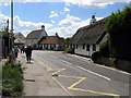
7

Sweechbridge Cottage
Thatched cottage at the triangular junction of Sweechbridge Road and Reculver Road.
Image: © David Anstiss
Taken: 8 Aug 2010
0.19 miles
8
![Hillborough buildings [4]](https://s0.geograph.org.uk/geophotos/07/05/84/7058440_adb230a3_120x120.jpg)
Hillborough buildings [4]
St Mary's Cottage is, probably, 17th century. Now partly stuccoed and partly pebbledashed, all under a thatch roof. Listed, grade II, with details at: https://historicengland.org.uk/listing/the-list/list-entry/1336864
Hillborough is a suburb of the town of Herne Bay, a seaside town on the Thames Estuary, some 6 miles north of Canterbury and about 4 miles east of Whitstable. It neighbours the ancient villages of Herne and Reculver.
Image: © Michael Dibb
Taken: 7 Sep 2021
0.19 miles