IMAGES TAKEN NEAR TO
Bishopstone Lane, HERNE BAY, CT6 6RP
Introduction
This page details the photographs taken nearby to Bishopstone Lane, CT6 6RP by members of the Geograph project.
The Geograph project started in 2005 with the aim of publishing, organising and preserving representative images for every square kilometre of Great Britain, Ireland and the Isle of Man.

There are currently over 7.5m images from over14,400 individuals and you can help contribute to the project by visiting https://www.geograph.org.uk
Image Map
Images are licensed for reuse under creativecommons.org/licenses/by-sa/2.0
Notes
- Clicking on the map will re-center to the selected point.
- The higher the marker number, the further away the image location is from the centre of the postcode.
Image Listing (28 Images Found)
Images are licensed for reuse under creativecommons.org/licenses/by-sa/2.0
Image
Details
Distance
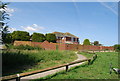
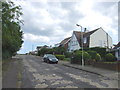
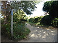
1
Hillborough Caravan Site today
This is what Hillborough Caravan Site looks like today - a housing development with a new roundabout on Reculver Road. It is almost unrecognizable from when my family and I used to spend our summer holidays here from the 70s right through to the 90s. The access road to the site is now a council-owned road called Sanderling Road and has several cul-de-sacs leading off it, whereas of course when the caravan site was opened it was simply a privately owned road and lead to a circular road surrounded by the caravans. The caravan site closed in 1998, probably because of lack of economy, as caravanning as a holiday activity has declined rapidly. I reckon even today it would've had problems in surviving, as I don't think many people could afford the rent for caravanning in these times of the credit crunch. View taken looking south-southeast towards Hillborough.
Image: © Robert Lamb
Taken: 14 Dec 2008
0.09 miles
3
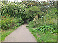
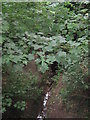
Path in Bishopstone Glen, Herne Bay
The coastal path swings inland around the short valley of Bishopstone Glen, formed by a gap between two sand cliffs.
Image: © Jim Barton
Taken: 8 Aug 2023
0.17 miles
4
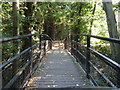
Footbridge at Bishopstone Glen
In the wooded area near to the Glen, which is a site of special scientific interest.
Image: © pam fray
Taken: 1 Oct 2011
0.18 miles
6
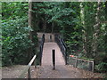
Footbridge in Bishopstone Glen
The Saxon Shore Way (long distance path) leads from Hillborough Cliff towards Bishopstone Lane, from Glenbervie Drive.
The bridge leads over the glen and stream.
Image: © David Anstiss
Taken: 8 Aug 2010
0.19 miles
7
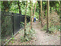
Path above Bishopstone Glen, Herne Bay
The railings fence off the steep bank of the stream below.
Image: © Jim Barton
Taken: 8 Aug 2023
0.20 miles
8
Bishopstone Glen
As seen from Image
The stream leads downhill towards the North Sea.
Image: © David Anstiss
Taken: 8 Aug 2010
0.20 miles
9
The Thanet Coastal Path above Bishopstone Glen
The Thanet Coastal Path has just passed the top of Bishopstone Glen and makes a left turn around the west side of the glen to reach Reculver Drive. The same route is followed by the Saxon Shore Way. A photograph of Bishopstone Glen can be seen at https://www.geograph.org.uk/photo/2113163
Image: © Marathon
Taken: 20 Aug 2020
0.20 miles