IMAGES TAKEN NEAR TO
Manor Road, HERNE BAY, CT6 6RF
Introduction
This page details the photographs taken nearby to Manor Road, CT6 6RF by members of the Geograph project.
The Geograph project started in 2005 with the aim of publishing, organising and preserving representative images for every square kilometre of Great Britain, Ireland and the Isle of Man.

There are currently over 7.5m images from over14,400 individuals and you can help contribute to the project by visiting https://www.geograph.org.uk
Image Map
Images are licensed for reuse under creativecommons.org/licenses/by-sa/2.0
Notes
- Clicking on the map will re-center to the selected point.
- The higher the marker number, the further away the image location is from the centre of the postcode.
Image Listing (71 Images Found)
Images are licensed for reuse under creativecommons.org/licenses/by-sa/2.0
Image
Details
Distance
1
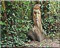
Wooden sculpture, Bishopstone Glen
Formerly the path here crossed through 'Fairy Woods' where local resident James Robinson had turned the bottom of his garden into an attraction with fairy houses, gnomes and crazy paving (from the information board on the coastal path).
Image: © Jim Barton
Taken: 8 Aug 2023
0.04 miles
4
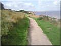
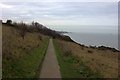
Saxon Shore Way at Bishopstone
The Saxon Shore Way has left Reculver Country Park behind and is heading to Bishopstone Glen, the top of which can just be seen beyond the bend in the path. Herne Bay is in the far distance, and the black speck on the right is the isolated end of Herne Bay Pier.
Image: © Marathon
Taken: 17 Sep 2010
0.05 miles
5
Wantsum Way looking towards Herne Bay at Bishopstone
Image: © Robert Eva
Taken: 2 Dec 2017
0.05 miles
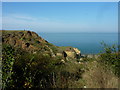
6
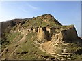
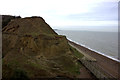
Bishopstone Glen, Beltinge
I have great memories from my childhood here and this site of special scientific interest is one that's changed in the last several years from erosion. I found a similar image taken by E Gammie in 1981 http://www.geograph.org.uk/photo/925495 and was amazed to see what this site looked like over 30 years ago so I went back out to re-photograph the site as it looks today. I think it's an important thing to document as places and things can change so rapidly over time.
Image: © Matt Allsop
Taken: 7 Apr 2015
0.06 miles
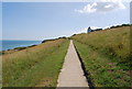
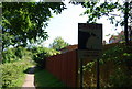
9
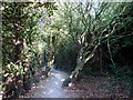
Footpath at Bishopstone Glen
Part of Reculver Country Park.
Image: © pam fray
Taken: 1 Oct 2011
0.06 miles
10
Bishopstone Glen, Beltinge
Viewed from the footpath to the eastern end.
Image: © pam fray
Taken: 1 Oct 2011
0.06 miles