IMAGES TAKEN NEAR TO
Lancaster Gardens, HERNE BAY, CT6 6PU
Introduction
This page details the photographs taken nearby to Lancaster Gardens, CT6 6PU by members of the Geograph project.
The Geograph project started in 2005 with the aim of publishing, organising and preserving representative images for every square kilometre of Great Britain, Ireland and the Isle of Man.

There are currently over 7.5m images from over14,400 individuals and you can help contribute to the project by visiting https://www.geograph.org.uk
Image Map
Images are licensed for reuse under creativecommons.org/licenses/by-sa/2.0
Notes
- Clicking on the map will re-center to the selected point.
- The higher the marker number, the further away the image location is from the centre of the postcode.
Image Listing (24 Images Found)
Images are licensed for reuse under creativecommons.org/licenses/by-sa/2.0
Image
Details
Distance
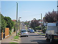
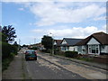
2
208, Reculver Road
Planning permission has been approved by Canterbury City Council under application number CA/21/02321 for a “detached dwelling with associated external works following demolition of existing bungalow”.
The view shows the bungalow during demolition.
Image: © John Baker
Taken: 17 Jul 2022
0.10 miles
4
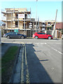
Building site, 175, Reculver Road
Planning permission was granted by Canterbury City Council under application number CA//15/02299 for the “demolition of the existing house and the erection of 3 three-storey dwellings”.
Image: © John Baker
Taken: 11 Mar 2018
0.13 miles
7
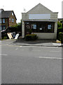
140, Reculver Road
It used to be a café called Famished.
Image: © John Baker
Taken: 26 May 2019
0.14 miles
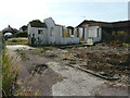
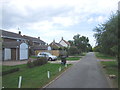
8
Building site, 227, Reculver Road
Planning permission has been granted by Canterbury City Council under application number CA//19/00408 for a “proposed two-storey detached dwelling together with detached single-storey garage/outbuilding to rear following demolition of existing detached dwelling”. The house, that has been demolished, was called Sunnybank.
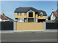
The view of Image shows the house, which now occupies the site.
Image: © John Baker
Taken: 26 May 2019
0.15 miles
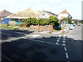
9
227, Reculver Road
In May 2019, the location was a Image
Image: © John Baker
Taken: 17 Jul 2022
0.15 miles
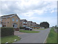
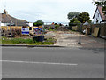
10
93, Osborne Gardens
Planning permission was granted by Canterbury City Council under application number CA//16/00047 for the “demolition of existing bungalow. Erection of two semi-detached bungalows with associated parking”.
Image: © John Baker
Taken: 10 Sep 2017
0.15 miles