IMAGES TAKEN NEAR TO
Terminus Drive, HERNE BAY, CT6 6PP
Introduction
This page details the photographs taken nearby to Terminus Drive, CT6 6PP by members of the Geograph project.
The Geograph project started in 2005 with the aim of publishing, organising and preserving representative images for every square kilometre of Great Britain, Ireland and the Isle of Man.

There are currently over 7.5m images from over14,400 individuals and you can help contribute to the project by visiting https://www.geograph.org.uk
Image Map
Images are licensed for reuse under creativecommons.org/licenses/by-sa/2.0
Notes
- Clicking on the map will re-center to the selected point.
- The higher the marker number, the further away the image location is from the centre of the postcode.
Image Listing (37 Images Found)
Images are licensed for reuse under creativecommons.org/licenses/by-sa/2.0
Image
Details
Distance
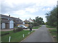
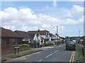
3
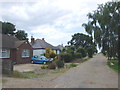
140, Reculver Road
It used to be a café called Famished.
Image: © John Baker
Taken: 26 May 2019
0.08 miles
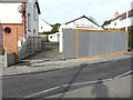
6
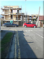
Building site, 175, Reculver Road
Planning permission was granted by Canterbury City Council under application number CA//15/02299 for the “demolition of the existing house and the erection of 3 three-storey dwellings”.
Image: © John Baker
Taken: 11 Mar 2018
0.11 miles
7
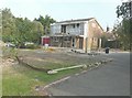
Moonraker, Lismore Road
Planning permission has been granted by Canterbury City Council under application number CA//14/02038 for “replacement front porch, first floor extension over garage, enclosure of open balcony at first floor level, 8 skylights to roof, cement fibre weatherboard cladding to external walls and internal alterations”. The house is now called Image
Image: © John Baker
Taken: 18 Sep 2014
0.11 miles
8
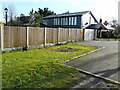
Ananda, Lismore Road
Compared with Image, work on the house has been completed, but it appears that its name has been changed, for I noted down the new name when taking the photograph. An internet search confirmed that the new name was related to planning application CA//14/02038.
Image: © John Baker
Taken: 25 Jan 2016
0.11 miles
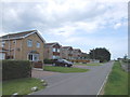
10
Redevelopment of East Cliff Garage, 133, Reculver Road
Planning permission has been granted by Canterbury City Council under application number CA//12/02220 for the “demolition of existing garages and erection of new residential dwelling”. The location was described as land adjacent to 133, Reculver Road.
The site is now occupied by this house at Image
Image: © John Baker
Taken: 25 Jan 2016
0.12 miles