IMAGES TAKEN NEAR TO
Sea View Road, HERNE BAY, CT6 6JG
Introduction
This page details the photographs taken nearby to Sea View Road, CT6 6JG by members of the Geograph project.
The Geograph project started in 2005 with the aim of publishing, organising and preserving representative images for every square kilometre of Great Britain, Ireland and the Isle of Man.

There are currently over 7.5m images from over14,400 individuals and you can help contribute to the project by visiting https://www.geograph.org.uk
Image Map
Images are licensed for reuse under creativecommons.org/licenses/by-sa/2.0
Notes
- Clicking on the map will re-center to the selected point.
- The higher the marker number, the further away the image location is from the centre of the postcode.
Image Listing (44 Images Found)
Images are licensed for reuse under creativecommons.org/licenses/by-sa/2.0
Image
Details
Distance
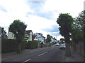
1
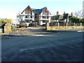
7, Sea View Road
Planning permission was granted by Canterbury City Council under application number CA//12/00810 for the “replacement of bungalow with a house”, which is the process of being built.
This was Image after its construction had been completed.
Image: © John Baker
Taken: 29 Dec 2013
0.02 miles
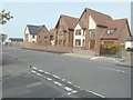
4
7, Sea View Road
This was Image when it was under construction.
Image: © John Baker
Taken: 1 Jul 2018
0.03 miles
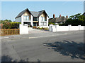
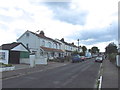
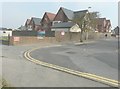
6
1 and 3, Kestrel View, Sea View Road
On 29 December 2013, these houses appeared as Image
Image: © John Baker
Taken: 18 Sep 2014
0.07 miles
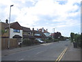
7
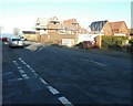
Building site at 1, Sea View Road
Seen from the junction with Alma Road. Planning permission has been granted by Canterbury City Council under application number CA//13/0393/FUL for the “erection of six detached dwellings and associated parking”. Milford House once stood here.
Image: © John Baker
Taken: 29 Dec 2013
0.07 miles
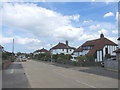
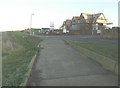
9
Kestrel View, The Lees
On 29 December 2013, these houses, taken from a little further away, appeared as Image The road is Sea View Road from where there is an entrance to Image, while the main entrance is from The Lees.
Image: © John Baker
Taken: 18 Sep 2014
0.08 miles
10
Building site at 1, Sea View Road
Seen from the path beside Beacon Hill. Planning permission has been granted by Canterbury City Council under application number CA//13/0393/FUL as the “erection of six detached dwellings and associated parking”.
Image: © John Baker
Taken: 29 Dec 2013
0.08 miles