IMAGES TAKEN NEAR TO
Mickleburgh Hill, HERNE BAY, CT6 6DU
Introduction
This page details the photographs taken nearby to Mickleburgh Hill, CT6 6DU by members of the Geograph project.
The Geograph project started in 2005 with the aim of publishing, organising and preserving representative images for every square kilometre of Great Britain, Ireland and the Isle of Man.

There are currently over 7.5m images from over14,400 individuals and you can help contribute to the project by visiting https://www.geograph.org.uk
Image Map
Images are licensed for reuse under creativecommons.org/licenses/by-sa/2.0
Notes
- Clicking on the map will re-center to the selected point.
- The higher the marker number, the further away the image location is from the centre of the postcode.
Image Listing (53 Images Found)
Images are licensed for reuse under creativecommons.org/licenses/by-sa/2.0
Image
Details
Distance
1
Proposed development at 42, Mickleburgh Hill
The proposed development of this site lies behind the hedge. Planning permission has been granted by Canterbury City Council under application number CA//16/01925 for the “proposed erection of dwelling with associated parking, following demolition of garage”. A copy of the planning application can be seen affixed to the lamppost.
Image: © John Baker
Taken: 11 Sep 2016
0.01 miles
3
42, Mickleburgh Hill
The Image has resulted in a house being built here.
Image: © John Baker
Taken: 10 Sep 2017
0.01 miles
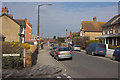
7
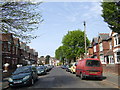
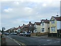
Oakdale Road, Herne Bay
A good example of a 1920's red-brick street.
Image: © Jonathan Billinger
Taken: 25 Apr 2007
0.09 miles
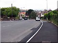
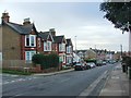
10
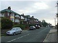
Mickleburgh Hill, Herne Bay
Looking West at the junction with Douglas Road.
Image: © Mark Anderson
Taken: 12 Apr 2012
0.12 miles