IMAGES TAKEN NEAR TO
HERNE BAY, CT6 5SS
Introduction
This page details the photographs taken nearby to CT6 5SS by members of the Geograph project.
The Geograph project started in 2005 with the aim of publishing, organising and preserving representative images for every square kilometre of Great Britain, Ireland and the Isle of Man.

There are currently over 7.5m images from over14,400 individuals and you can help contribute to the project by visiting https://www.geograph.org.uk
Image Map
Images are licensed for reuse under creativecommons.org/licenses/by-sa/2.0
Notes
- Clicking on the map will re-center to the selected point.
- The higher the marker number, the further away the image location is from the centre of the postcode.
Image Listing (99 Images Found)
Images are licensed for reuse under creativecommons.org/licenses/by-sa/2.0
Image
Details
Distance
2
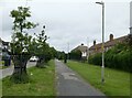
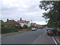
Station Chine, Herne Bay
The path leads to Herne Bay Memorial Park.
Image: © pam fray
Taken: 29 Jun 2021
0.03 miles
3

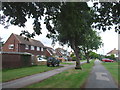
4, Dering Road
Planning permission has been granted by Canterbury City Council under application number CA/20/00870 for the “proposed demolition of garage”.
A fence (seen here behind the car) has been erected in front of the garage.
Image: © John Baker
Taken: 14 Jun 2020
0.03 miles
7
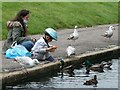
Feeding the ducks, Herne Bay
The lake is in Herne Bay Memorial Park. The park was established following the end of World War I on land which was marshy and undeveloped. Following the armistice in 1918 a local committee met and proposed a new park for Herne Bay to commemorate the men that had lost their lives in World War I.
Image: © pam fray
Taken: 29 Jun 2021
0.07 miles
8
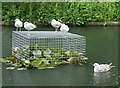
The lake in Herne Bay Memorial Park
The gulls are perched on a wire cage protecting the water lilies. The park was established following the end of World War I on land which was marshy and undeveloped. Following the armistice in 1918 a local committee met and proposed a new park for Herne Bay to commemorate the men that had lost their lives in World War I.
Image: © pam fray
Taken: 29 Jun 2021
0.08 miles
10

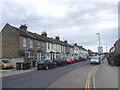
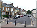
Former 83 William Street, Herne Bay
Now split into about 6 flats it was previously a shop, off-licence and house. On the OS map it is marked as a brewery between 1898 and 1908 and backs up what I was told by previous owners. The only brewery I can find listed for William Street (but with no mention of its location) is Burton Brewery that had moved to William Street by 1874 and was owned by Richard Sydney King in 1882. It was known as G.E.Furber, Burton Brewery between 1888 and 1895 and Flinn & Co. Burton Brewery and Mineral Water Works between 1895 and 1905. Joseph Flinn's two sons took over the brewery but their partnership was dissolved in 1894. Harry went to Canada for two years but returned to run the brewery. He purchased the concern outright in 1902 for £4,566 which included two pubs in Dover. In 1904 Harry Flinn filed his own petition for bankruptcy. Burton Brewery Co was formed after Flinn’s bankruptcy; brewing continued but had ceased by 1910. The brewing plant was dismantled and removed in 1911 and the premises became a store for the Canterbury Brewery Co with a taphouse and off-licence. Based on the OS map, part of the brewery was also demolished around this time. The stores were in use by Messrs Fremlins Ltd in 1934.
Image: © Jo and Steve Turner
Taken: 6 Jul 2016
0.09 miles