IMAGES TAKEN NEAR TO
Kings Road, HERNE BAY, CT6 5RP
Introduction
This page details the photographs taken nearby to Kings Road, CT6 5RP by members of the Geograph project.
The Geograph project started in 2005 with the aim of publishing, organising and preserving representative images for every square kilometre of Great Britain, Ireland and the Isle of Man.

There are currently over 7.5m images from over14,400 individuals and you can help contribute to the project by visiting https://www.geograph.org.uk
Image Map
Images are licensed for reuse under creativecommons.org/licenses/by-sa/2.0
Notes
- Clicking on the map will re-center to the selected point.
- The higher the marker number, the further away the image location is from the centre of the postcode.
Image Listing (248 Images Found)
Images are licensed for reuse under creativecommons.org/licenses/by-sa/2.0
Image
Details
Distance
1

Entrance gate to The Avenue of Remembrance, Herne Bay
Detail of the gate that leads into Herne Bay Memorial Park.
Image: © pam fray
Taken: 3 Sep 2022
0.03 miles
2

Entrance gate to the Avenue of Remembrance, Herne Bay
Detail of the gate that leads into Herne Bay Memorial Park.
Image: © pam fray
Taken: 3 Sep 2022
0.03 miles
3
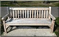
Seat in Herne Bay Memorial Park
Several of these seats, commemorating the battles of the First World War, flank the Avenue of Remembrance. This one has the inscription "Mons 1914".
Image: © pam fray
Taken: 3 Sep 2022
0.04 miles
4
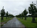
Avenue of Remembrance, Herne Bay
An entrance to Herne Bay Memorial Park leading from Kings Road to the war memorial. Unfortunately the horse chestnuts in the Avenue of Remembrance were felled in December 2016 after finding the bleeding canker bacteria. Sadly there is no effective treatment for canker so they were removed and replaced with hornbeams.
Image: © pam fray
Taken: 29 Jun 2021
0.05 miles
7
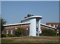
Building in Herne Bay Memorial Park
It houses Poppy Children's Centre. Viewed from the Avenue of Remembrance.
Image: © pam fray
Taken: 22 Sep 2020
0.08 miles
9
The Avenue of Remembrance, Herne Bay
Looking towards the memorial gates in Herne Bay Memorial Park. The Avenue of Remembrance and the memorial gates were added in 1945.
Image: © pam fray
Taken: 3 Sep 2022
0.09 miles
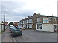
10
74, High Street
This used to be the Image Planning permission has been granted by Canterbury City Council under application number CA//17/02055 for a “proposed three, four, and five-storey mixed use development comprising of 900 sq m of retail floor space to the High Street frontage together with twenty one 3-bed dwellings, two 1-bed flats and twenty-seven 2-bed flats together with access, parking and courtyard amenity area following demolition of the existing buildings”.
Image: © John Baker
Taken: 26 May 2019
0.09 miles