IMAGES TAKEN NEAR TO
Station Road, HERNE BAY, CT6 5NA
Introduction
This page details the photographs taken nearby to Station Road, CT6 5NA by members of the Geograph project.
The Geograph project started in 2005 with the aim of publishing, organising and preserving representative images for every square kilometre of Great Britain, Ireland and the Isle of Man.

There are currently over 7.5m images from over14,400 individuals and you can help contribute to the project by visiting https://www.geograph.org.uk
Image Map
Images are licensed for reuse under creativecommons.org/licenses/by-sa/2.0
Notes
- Clicking on the map will re-center to the selected point.
- The higher the marker number, the further away the image location is from the centre of the postcode.
Image Listing (56 Images Found)
Images are licensed for reuse under creativecommons.org/licenses/by-sa/2.0
Image
Details
Distance
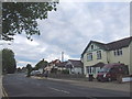
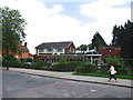
1
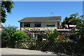
Saint Mary's Court, Station Road, Herne Bay
Image: © Robert Eva
Taken: 9 Nov 2017
0.01 miles
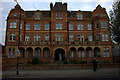
2
St, Mary's Court, Herne Bay
Large building on Station Road.
Former Hotel and Youth Hostel.
Image: © David Anstiss
Taken: 8 Aug 2010
0.02 miles
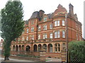
4
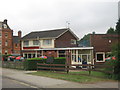
The Heron Public House, Herne Bay
On Station Road, close to Herne Bay Railway Station.
St Mary's Court is in the background.
Image: © David Anstiss
Taken: 8 Aug 2010
0.03 miles
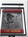
5
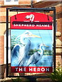
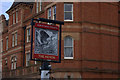
Sign for the Heron public house, Herne Bay
See Image] for public house.
Image: © JThomas
Taken: 22 Jun 2022
0.03 miles
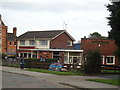
8
The Heron public house, Herne Bay
On Station Road.
See Image] for sign.
Image: © JThomas
Taken: 22 Jun 2022
0.04 miles
9
The Heron, pub sign
St Mary's Court in the background
Image: © Robert Eva
Taken: 9 Nov 2017
0.05 miles