IMAGES TAKEN NEAR TO
Victoria Park, HERNE BAY, CT6 5BH
Introduction
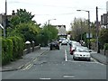
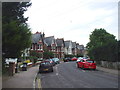
This page details the photographs taken nearby to Victoria Park, CT6 5BH by members of the Geograph project.
The Geograph project started in 2005 with the aim of publishing, organising and preserving representative images for every square kilometre of Great Britain, Ireland and the Isle of Man.

There are currently over 7.5m images from over14,400 individuals and you can help contribute to the project by visiting https://www.geograph.org.uk
Image Map
Images are licensed for reuse under creativecommons.org/licenses/by-sa/2.0
Notes
- Clicking on the map will re-center to the selected point.
- The higher the marker number, the further away the image location is from the centre of the postcode.
Image Listing (185 Images Found)
Images are licensed for reuse under creativecommons.org/licenses/by-sa/2.0
Image
Details
Distance
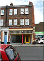
4
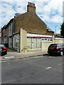
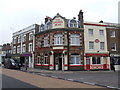
212, High Street
It used to be a shop called Woodstock, which specialized in fitted furniture.
Image: © John Baker
Taken: 26 May 2019
0.09 miles
8
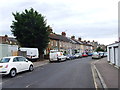
201, High Street
It used to be a shop called S.A.M. SPARES, which specialized in discount car parts and accessories.
Image: © John Baker
Taken: 26 May 2019
0.11 miles