IMAGES TAKEN NEAR TO
High Street, HERNE BAY, CT6 5AJ
Introduction
This page details the photographs taken nearby to High Street, CT6 5AJ by members of the Geograph project.
The Geograph project started in 2005 with the aim of publishing, organising and preserving representative images for every square kilometre of Great Britain, Ireland and the Isle of Man.

There are currently over 7.5m images from over14,400 individuals and you can help contribute to the project by visiting https://www.geograph.org.uk
Image Map
Images are licensed for reuse under creativecommons.org/licenses/by-sa/2.0
Notes
- Clicking on the map will re-center to the selected point.
- The higher the marker number, the further away the image location is from the centre of the postcode.
Image Listing (297 Images Found)
Images are licensed for reuse under creativecommons.org/licenses/by-sa/2.0
Image
Details
Distance

2
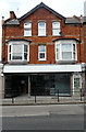
163-165, High Street
It used to be a shop called Pashley’s Cake Emporium.
Image: © John Baker
Taken: 26 May 2019
0.01 miles

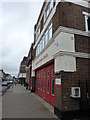
6
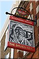
Druids Head sign
Sign for the Druids Head, a Shepherd Neame pub on High Street.
Image: © Oast House Archive
Taken: 22 Apr 2018
0.03 miles

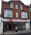
8
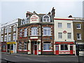
Druid's Head Public House, Herne Bay
On junction of High Street (in front) and Bank Street (on right).
Image: © David Anstiss
Taken: 13 Apr 2009
0.04 miles
9
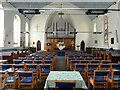
The United Church, Herne Bay
In Mortimer Street, open today to show an exhibition of local artists.
Image: © pam fray
Taken: 3 Sep 2022
0.04 miles