IMAGES TAKEN NEAR TO
Nightingale Avenue, WHITSTABLE, CT5 4TR
Introduction
This page details the photographs taken nearby to Nightingale Avenue, CT5 4TR by members of the Geograph project.
The Geograph project started in 2005 with the aim of publishing, organising and preserving representative images for every square kilometre of Great Britain, Ireland and the Isle of Man.

There are currently over 7.5m images from over14,400 individuals and you can help contribute to the project by visiting https://www.geograph.org.uk
Image Map
Images are licensed for reuse under creativecommons.org/licenses/by-sa/2.0
Notes
- Clicking on the map will re-center to the selected point.
- The higher the marker number, the further away the image location is from the centre of the postcode.
Image Listing (28 Images Found)
Images are licensed for reuse under creativecommons.org/licenses/by-sa/2.0
Image
Details
Distance
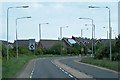
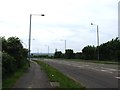
8
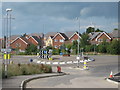
Roundabout on A2990 Thanet Way
This roundabout is on the link road from the A299 dual carriage way leading from the M2 Motorway to the Thanet Way towns. It is seen from Estuary View Business Park access road.
Image: © David Anstiss
Taken: 25 Jul 2009
0.19 miles
9
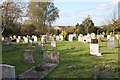
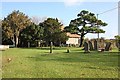
St Alphege church, Seasalter, Kent - Churchyard
Image: © John Salmon
Taken: 16 Oct 2008
0.19 miles