IMAGES TAKEN NEAR TO
Hilltop, Stanley Road, WHITSTABLE, CT5 4QE
Introduction
This page details the photographs taken nearby to Hilltop, Stanley Road, CT5 4QE by members of the Geograph project.
The Geograph project started in 2005 with the aim of publishing, organising and preserving representative images for every square kilometre of Great Britain, Ireland and the Isle of Man.

There are currently over 7.5m images from over14,400 individuals and you can help contribute to the project by visiting https://www.geograph.org.uk
Image Map
Images are licensed for reuse under creativecommons.org/licenses/by-sa/2.0
Notes
- Clicking on the map will re-center to the selected point.
- The higher the marker number, the further away the image location is from the centre of the postcode.
Image Listing (31 Images Found)
Images are licensed for reuse under creativecommons.org/licenses/by-sa/2.0
Image
Details
Distance
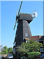
3
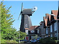
The Black Mill
This smock mill was built in 1815; it was originally painted white, but was tarred in 1885 https://en.wikipedia.org/wiki/Black_Mill,_Whitstable .
Image: © Mike Quinn
Taken: 21 Sep 2016
0.16 miles
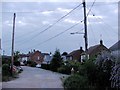
10
The Four Horseshoes, Whitstable
Here is a comparative picture from five years previously: http://www.geograph.org.uk/photo/1439001
Image: © Chris Whippet
Taken: 5 May 2014
0.19 miles