IMAGES TAKEN NEAR TO
Saddleton Grove, Saddleton Road, WHITSTABLE, CT5 4LY
Introduction
This page details the photographs taken nearby to Saddleton Grove, Saddleton Road, CT5 4LY by members of the Geograph project.
The Geograph project started in 2005 with the aim of publishing, organising and preserving representative images for every square kilometre of Great Britain, Ireland and the Isle of Man.

There are currently over 7.5m images from over14,400 individuals and you can help contribute to the project by visiting https://www.geograph.org.uk
Image Map
Images are licensed for reuse under creativecommons.org/licenses/by-sa/2.0
Notes
- Clicking on the map will re-center to the selected point.
- The higher the marker number, the further away the image location is from the centre of the postcode.
Image Listing (85 Images Found)
Images are licensed for reuse under creativecommons.org/licenses/by-sa/2.0
Image
Details
Distance
3
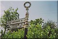
Old Direction Sign - Signpost on Canterbury Road, Whitstable
3 arms and annulus finial; Kent CC parish halo by the A290, in Whitstable parish (Canterbury District), on the north side of the T junction of the B2205 Canterbury Road and Joy Lane.
surveyed
Milestone Society National ID: KE_TR1065
Image: © Milestone Society
Taken: 19 Jun 2007
0.09 miles
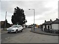
5
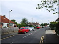
Looking east-southeast along Forge Lane
Compared with Image, the semi-detached house has been given the numbers 75 and 77. Its address is probably referred to as being in Essex Street.
Image: © John Baker
Taken: 25 Dec 2014
0.10 miles
6
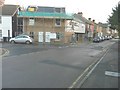
Buildings under construction
They are located on the corner of Essex Street and Forge Lane. Planning permission has been granted by Canterbury City Council under application number CA//12/00938 for the “demolition of hall and erection of semi-detached dwellings and one single bed unit (revised scheme)”. The hall was a single-storey building, probably used as a venue for community meetings.
Image: © John Baker
Taken: 24 Nov 2013
0.10 miles
7
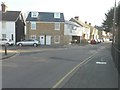
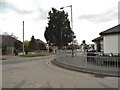
Joy Lane at the junction of Canterbury Road
Image: © David Howard
Taken: 19 Mar 2017
0.10 miles
9
Joy Lane at the junction of Canterbury Road
Image: © David Howard
Taken: 19 Mar 2017
0.10 miles