IMAGES TAKEN NEAR TO
Essex Street, WHITSTABLE, CT5 4HW
Introduction
This page details the photographs taken nearby to Essex Street, CT5 4HW by members of the Geograph project.
The Geograph project started in 2005 with the aim of publishing, organising and preserving representative images for every square kilometre of Great Britain, Ireland and the Isle of Man.

There are currently over 7.5m images from over14,400 individuals and you can help contribute to the project by visiting https://www.geograph.org.uk
Image Map
Images are licensed for reuse under creativecommons.org/licenses/by-sa/2.0
Notes
- Clicking on the map will re-center to the selected point.
- The higher the marker number, the further away the image location is from the centre of the postcode.
Image Listing (174 Images Found)
Images are licensed for reuse under creativecommons.org/licenses/by-sa/2.0
Image
Details
Distance
5
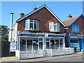
The Seven Seas Fish Bar & Restaurant, Canterbury Road
Image: © Mike Quinn
Taken: 21 Sep 2016
0.04 miles
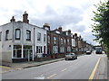
8
Canterbury Road, Whitstable
Waiting for the single-file traffic lights to change under the railway bridge ahead.
Image: © Phillip Perry
Taken: 23 Sep 2008
0.04 miles
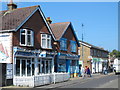
9
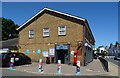
Co-op on Canterbury Road, Whitstable
Showing position of Postbox No. CT5 92.
See Image] for postbox.
Image: © JThomas
Taken: 22 Jun 2022
0.05 miles
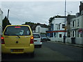
10
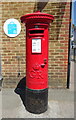
George V postbox on Canterbury Road, Whitstable
Postbox No. CT5 92.
See Image] for context.
Image: © JThomas
Taken: 22 Jun 2022
0.05 miles